As the population of San Francisco increases over time, the City must adapt its existing footprint to meet the capacity required by new residents and workers. This means that the transportation system must be made more efficient to handle increased ridership and shifts to different modes. San Francisco’s sidewalks and public right-of-way must be enhanced so that pedestrians can move about safely. Furthermore, residents must have access to open space that provide opportunities for recreation and respite.
To accommodate increases in population, the Planning Department may amend the San Francisco General Plan by creating an area plan, which guides the land use and other aspects of development for that specific geographic area. Seven area plans implemented by the Planning Department have development impact fees to fund infrastructure located in those neighborhoods: Balboa Park, Eastern Neighborhoods, Market Octavia, Rincon Hill, Transit Center, Visitacion Valley, and SoMa.
Impact fees are one of the various sources of funds that departments access in order to implement infrastructure projects in the Plan Areas. These sources may include the San Francisco General Fund, bonds, grant monies from the federal government, the State of California or private philanthropy, and other local funds such as Proposition K sales tax dollars and revenues from Community Facilities Districts (CFD). In recent years, impact fee revenue has declined due to slowed development during the COVID-19 pandemic.
City departments have planned infrastructure projects to be implemented in the next ten years in these neighborhoods. At the time of publication, the estimated cost of these projects was approximately $1.98 billion. To date, approximately $1.76 billion has been identified to fund these projects, leaving over to $200 million deferred. The City continues to seek sources in order to complete these projects. The following pages represent the spending plan and sources of funds for each Plan Area.
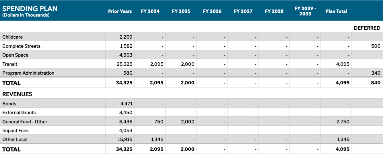
Balboa Park
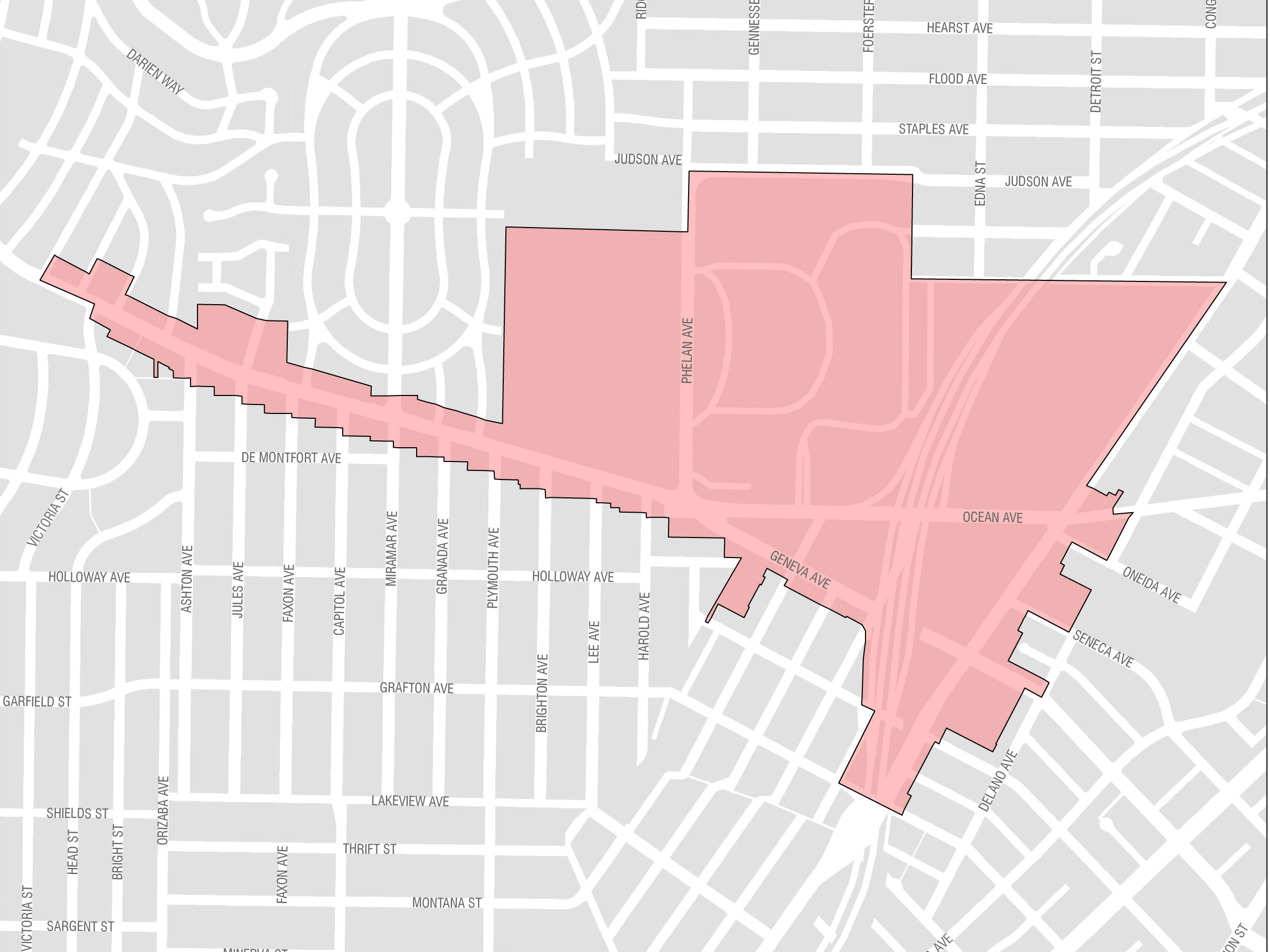
Balboa Park is located in southern San Francisco and provides several amenities that can be leveraged to promote a more livable neighborhood. The area includes the Ocean Avenue campus of the City College of San Francisco, the Ocean Avenue Neighborhood Commercial District, Balboa Park, and the Balboa Park BART station. The area is home to the Balboa Park Reservoir, where 1,100 units of housing are slated for development.
Key projects to be implemented in Balboa Park during the period of this Plan include streetscape projects along Geneva and Ocean Avenues, and several Muni Forward transit improvements. The Balboa Park spending plan is shown in the tables below.
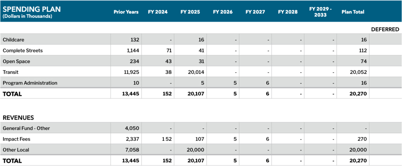
Eastern Neighborhoods
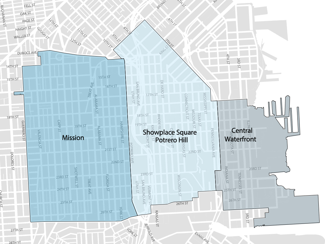
The Eastern Neighborhoods Area Plan consists of several smaller neighborhoods, including the Mission, Showplace Square/Potrero Hill, and Central Waterfront. Much of the land use in the Eastern Neighborhoods was historically dedicated to industrial uses, and production, distribution, and repair. Over time, residential and commercial uses have grown. In 2010, population in the Eastern Neighborhoods Plan Area was 83,930. The Planning Department projects the population to reach 149,570 by 2040, an increase of 78%.
Population growth has led to an increase in demand for infrastructure related to complete streets, transportation, and open space. Since the Eastern Neighborhoods Area Plan was initiated in 2008, the City has worked with the community to identify priority projects for implementation. These priorities include a number of projects from the 2008 Area Plan as well as new projects identified through planning efforts that occurred since the Plan was first adopted.
The revenues estimated for projects in Eastern Neighborhoods is approximately $118 million, including prior years. The tables on the following page show the Eastern Neighborhoods spending plan, sources of funds, and funding gap.
|
Key Proposed Eastern Neighborhoods Projects through 2033 |
|---|
|
Complete Streets |
|
Mariposa Bike Connection |
|
Minnesota / 25th Street Improvements (Minnesota Grove) |
|
17th Street / Vermont / San Bruno Improvements (“The Potrero Gateway”) |
|
Transit |
|
16th Street / 22-Fillmore Improvement Project |
|
14-Mission: Outer Mission - Mission Bay Loop |
|
Recreation and Open Space |
|
Jackson Playground Renovation |
|
Esprit Park Renovation |
Spending Plan: Eastern Neighborhoods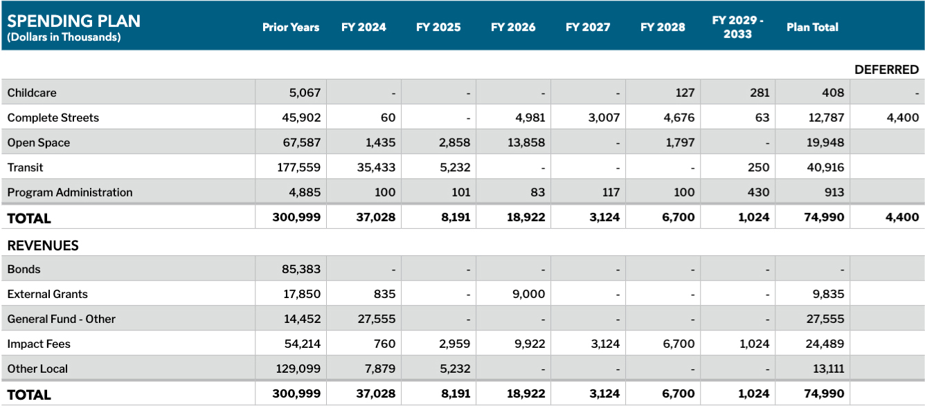
SoMa
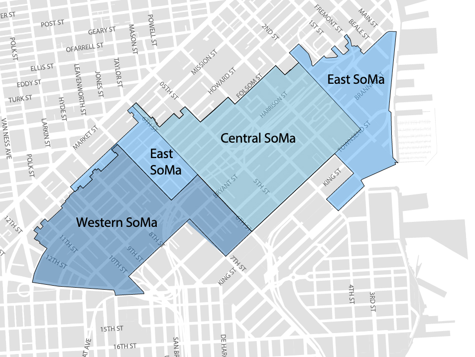
SoMa includes three Area Plan geographies: Western SoMa, Central SoMa, and Eastern SoMa. The Central SoMa Plan is the most recently approved, enables the most significant amount of additional growth, and creates the greatest amount of potential revenue through new impact fees and the establishment of a CFD to pay for new infrastructure projects. The vision of the Central SoMa Plan is to create a social, economic, and environmentally sustainable neighborhood by 2040, with space for approximately 32,000 new jobs and 8,600 new housing units. The Plan is expected to result in up to $2.2 billion in public benefits to serve critical needs of the neighborhood, including affordable housing, transportation, streets improvements, parks and recreation, schools, environmental sustainability, and community services. Funding for these projects will be derived from a combination of new and existing impact fees, CFD special tax revenues, direct provision by developers, and various other sources of funding. These funds will be received as development occurs in the Plan Area over the next 25 years.
The revenues estimated for projects in SoMa is approximately $260 million, including prior years. The tables on the following page show the SoMa spending plan, and sources of funds.
|
Key Proposed SoMa Projects through 2033 |
|---|
|
Complete Streets |
|
Folsom / Howard Streetscape |
|
5th Street Bike Strategy |
|
6th Street Improvements |
|
Street Tree Nursery |
|
Transit |
|
27 Bryant Tenderloin Project |
|
Mission: Spear to 11th Rapid Project |
|
Recreation and Open Space |
|
Gene Friend Recreation Center Rebuild |
|
New 11th & Natoma Park |
|
Gene Friend Pool Annex / 88 Bluxome |
|
New Park at Welsh / Freelon / 598 Brannan (in-kind) |
Spending Plan: SoMa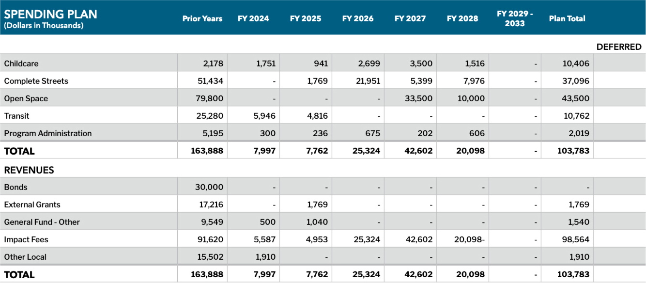
Market Octavia
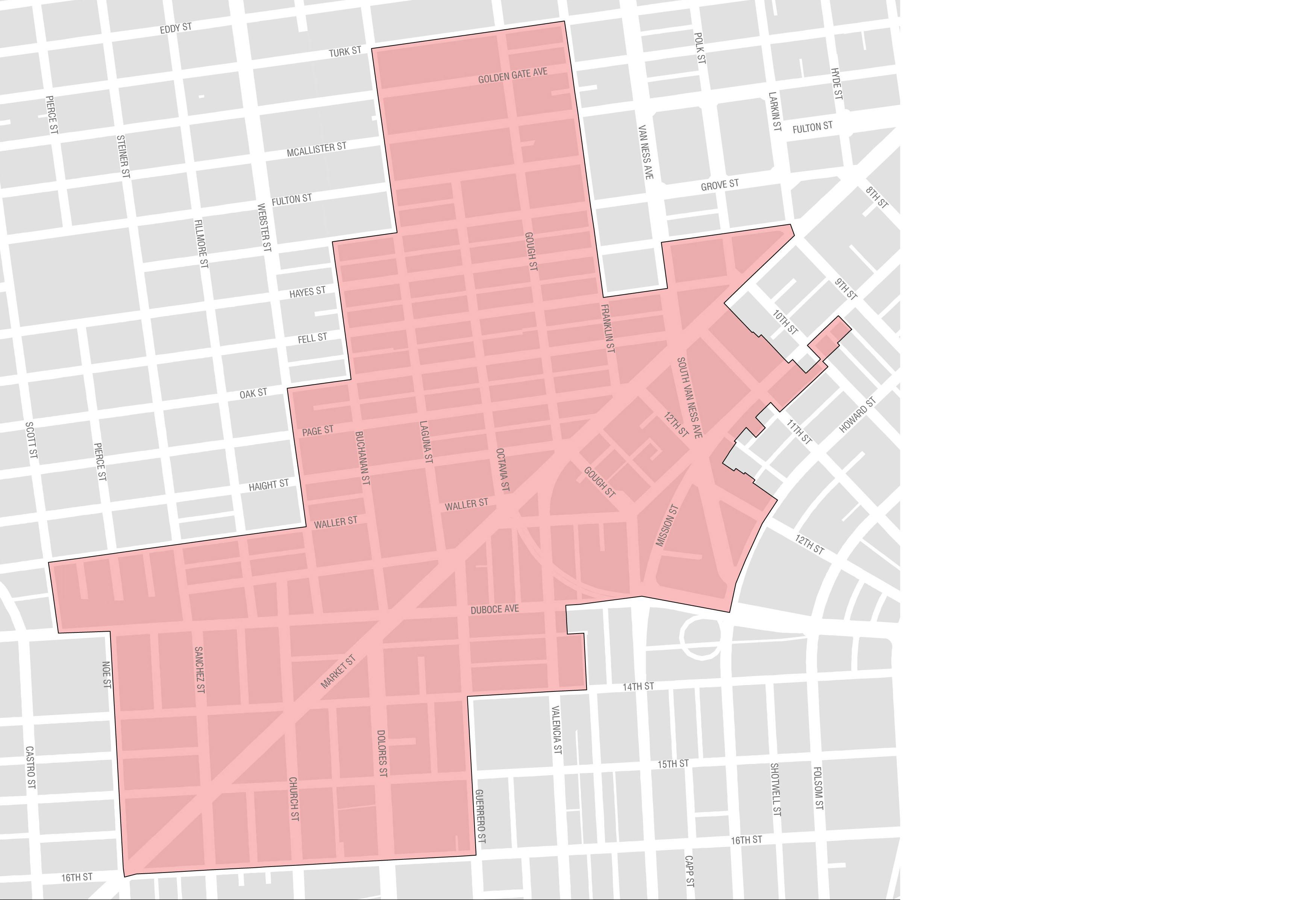
Market Octavia is located just west of the Civic Center, where governmental and cultural institutions attract visitors both day and night. Its pattern of streets and alleys make it walkable and bikeable. More than a dozen transit lines cross the neighborhood, including all of the city’s core streetcar lines. It is accessible from the entire Bay Area by BART and the regional freeway system.
Market Octavia’s history as a crossroads also poses enormous challenges. Large redevelopment projects occurred in the 1960s and 1970s, and the Central Freeway bisected the neighborhood before it was demolished in 2003. Large volumes of automobiles are channeled through the area creating hazardous conditions for pedestrians. However, its centrality and transit accessibility make Market Octavia a key area to add new housing to the city.
The Market Octavia Area Plan identified many needs related to complete streets, transit, open space, and childcare that will provide the necessary services for new people living and working in the area. The total estimated impact fee revenues for proposed projects in Market Octavia is currently estimated at $190 million, including prior years. The following tables show the Market Octavia spending plan, sources of funds, and funding gap.
|
Key Proposed Market Octavia Projects through 2033 |
|---|
|
Complete Streets |
|
Better Market Street |
|
13th Street Protected Bike Lanes |
|
Upper Market Pedestrian Improvements |
|
Octavia Boulevard Enhancement |
|
Page Street Neighborway |
|
One Oak Plaza (in-kind) |
|
30 Otis Plaza (in-kind) |
|
Transit |
|
Van Ness Bus Rapid Transit |
|
Valencia Bikeway |
|
Muni Light Rail Expansion |
|
Western Addition Community-Based Transportation Plan Improvements |
|
Recreation and Open Space |
|
Buchanan Street Mall |
|
Hub Open Space Improvements |
|
Rotating Public Art at Patricia’s Green |
|
Koshland Park |
Spending Plan: Market Octavia
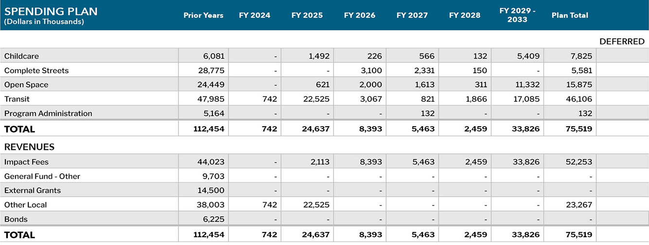
Transit Center
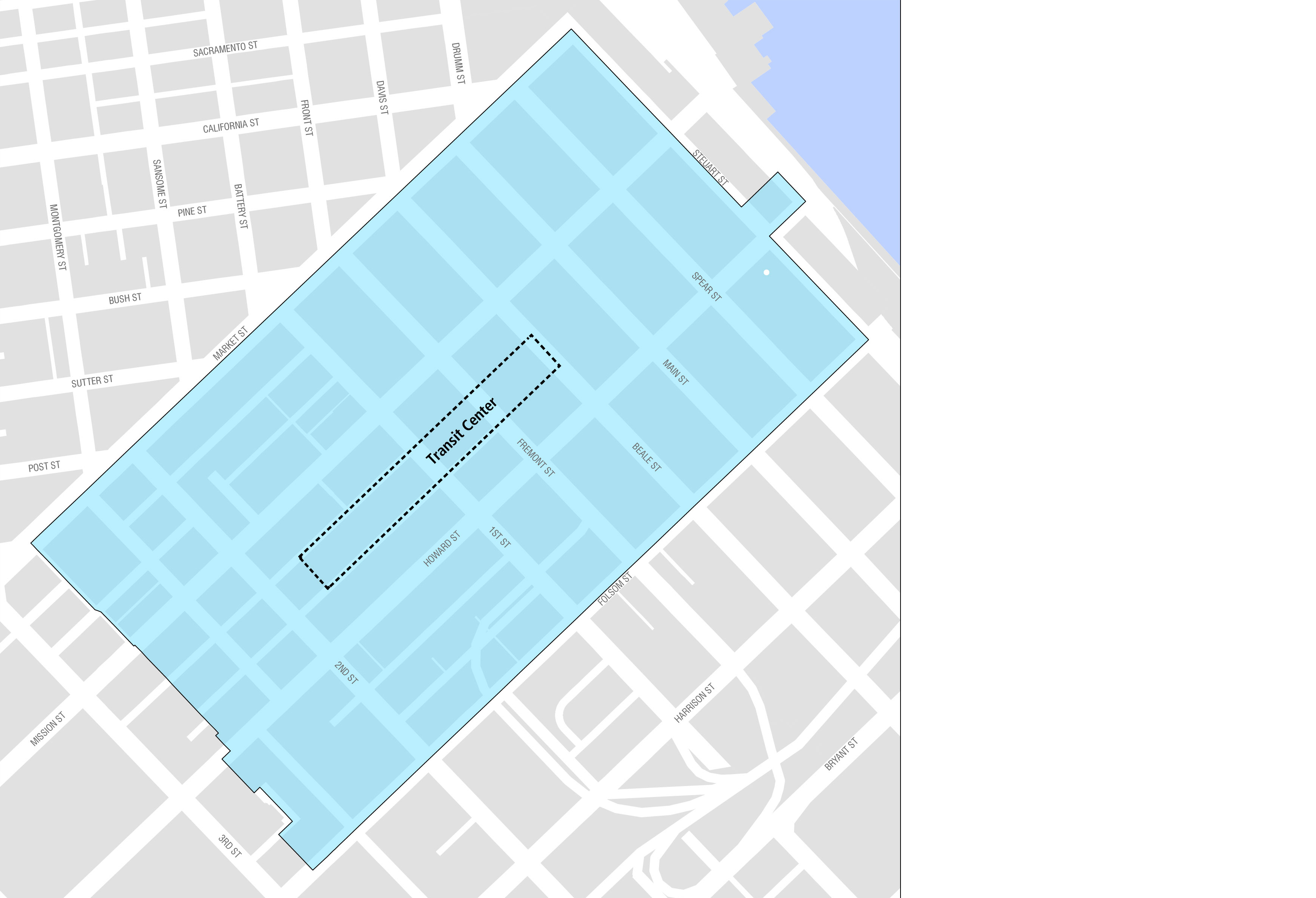
The Transit Center District Plan was adopted in 2012 to provide infrastructure improvements in conjunction with the opening of the Salesforce Transit Center. The Salesforce Transit Center is a $2.2 billion transportation hub that replaces the old Transbay Terminal and connects 11 regional transportation providers to downtown San Francisco. In addition to passengers arriving at the Transit Center, the Plan also includes several commercial developments.
The complete streets, transportation, and open space projects are designed to accommodate daily passenger traffic. The Plan includes those projects to be implemented by City agencies, with additional projects to be completed by external agencies such as the Caltrain Downtown Extension (known as DTX), BART underground pedestrian connector, open space projects to be performed by OCII, and sustainable resource district projects.
In addition to Impact Fees as a primary source of funding infrastructure projects, the Transit Center District Plan has also implemented a CFD special use tax that will provide funding for projects in the neighborhood. The total revenues, including impact fees and CFD taxes, estimated for the proposed projects in the Transit Center District is $890 million, including prior years. The tables on the following page show the Transit Center District spending plan, sources of funds, and funding gap.
|
Key Proposed Transit Center Projects through 2033 |
|---|
|
Complete Streets |
|
District-wide Streetscape and Pedestrian Improvements |
|
Better Market Street |
|
Transit |
|
Caltrain Downtown Extension (DTX) |
|
BART Station Capacity Improvements |
|
Congestion Charging Pilot Transit Delay Mitigation |
|
Transit Mitigation for new buses |
|
Recreation and Open Space |
|
Portsmouth Square Improvements |
|
Central Subway |
|
Transbay Block 3 Park |
|
Under Ramp Park |
Spending Plan: Transit Center
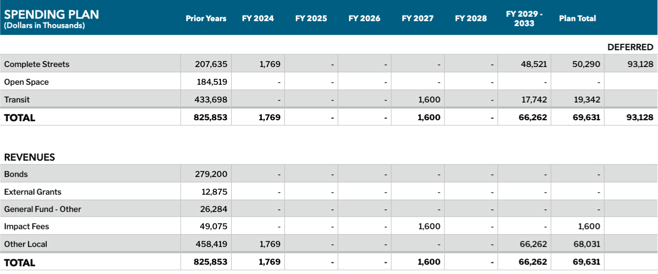
Rincon Hill
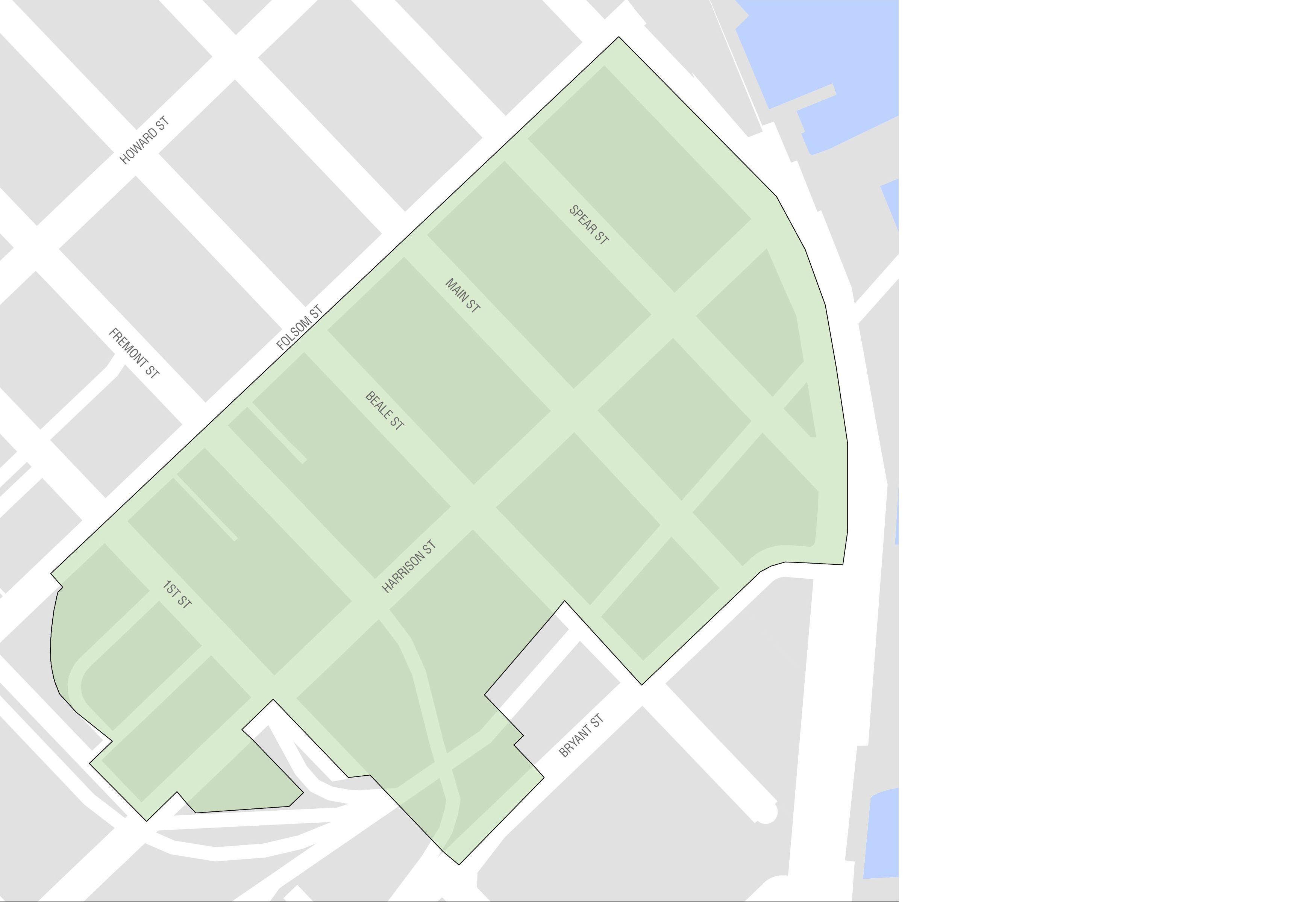
Rincon Hill is located in the northeast section of San Francisco, close to the Bay Bridge. Historically the neighborhood has contained many vacant lots and underutilized parcels, which have been rezoned for housing. Additionally, new parcels were opened up for development after the Embarcadero Freeway was demolished in 1991. Rincon Hill is accessible to many transit lines including the Muni Metro system and BART at Embarcadero station, which make Rincon Hill a strategic area to construct new housing in San Francisco.
Key streetscape projects in Rincon Hill include: First, Harrison, and Fremont Streets. A new mini-park at Guy Place opened in the summer of 2020. The Rincon Hill spending plan is shown below.
Spending Plan: Rincon Hill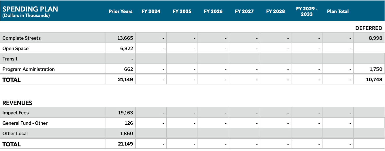
Visitacion Valley
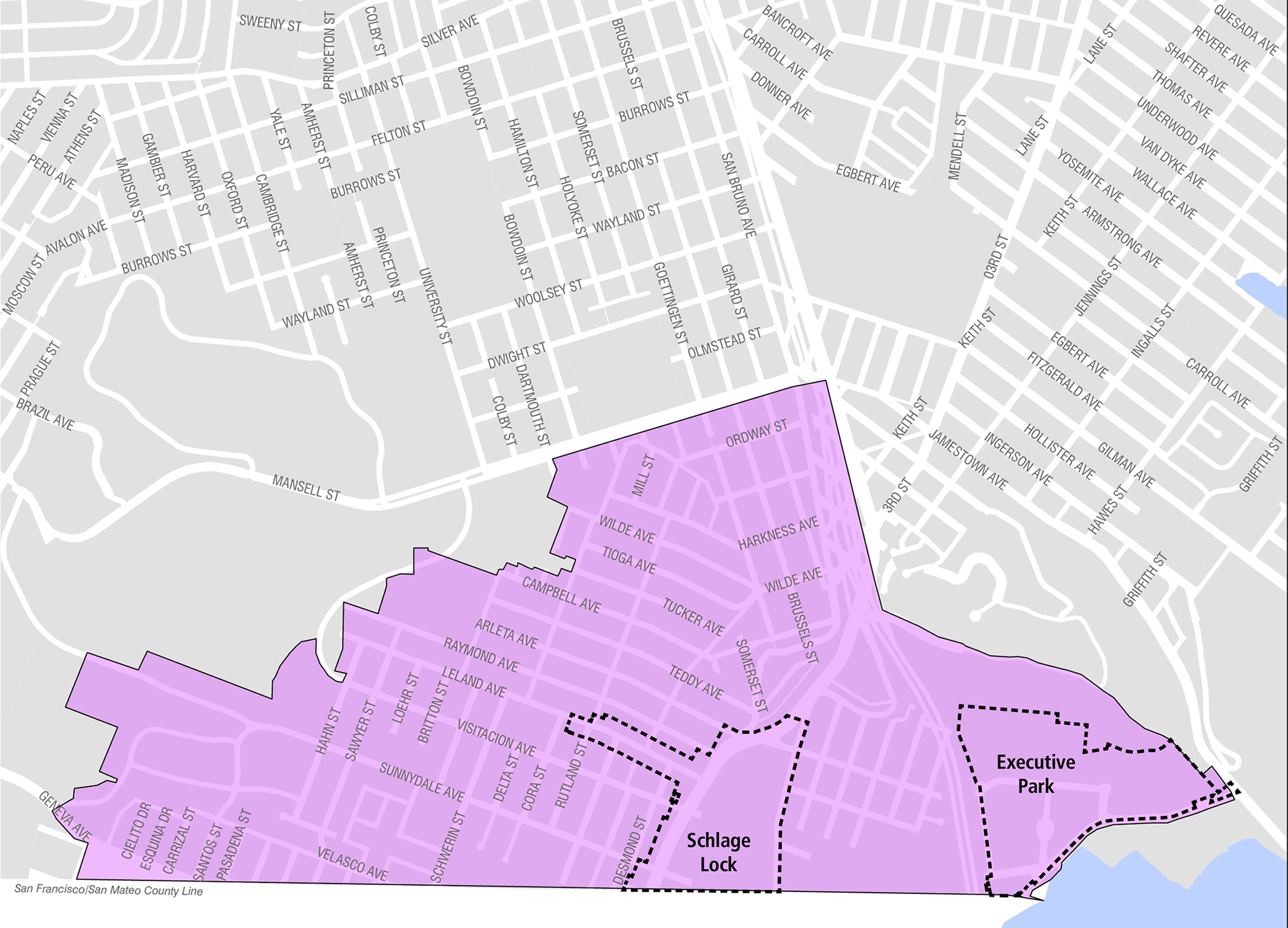
Visitacion Valley is located in southeast San Francisco, near the Brisbane border. In 1999, the Schlage Lock company decided to close its factory located in the area. The now-vacant site presents opportunities for new uses. New developments in the area are expected to produce a net increase of 4,800 housing units, 140,000 square feet of commercial/retail space, and 75,000 square feet of community space over at least ten years. An impact fee was implemented in 2005 for Visitacion Valley in anticipation of higher density development planned for Executive Park, the sub-area immediately east of the 101 Highway, Sunnydale HOPE SF, and Schlage Lock.
There is no area plan for Visitacion Valley, however, several enhancement projects are planned including Geneva Harney Bus Rapid Transit, 8-Bayshore Transit Priority Project, Herz Playground rehabilitation, and Schlage Lock streetscape improvement and parks projects. The Visitacion Valley spending plan is shown below.
Spending Plan: Visitacion Valley