As we consider the next generation of programs and projects that will build strong, adaptive, and sustainable communities in San Francisco, two strategic documents will serve as guides: the Hazards and Climate Resilience Plan and the Climate Action Strategy.
To be completed in 2019, the Hazards and Climate Resilience Plan is San Francisco’s resilience plan to assess its vulnerability to existing hazards, such as earthquakes, as well as hazards increasing due to climate change, such as flooding, drought, and extreme heat. The plan will include hazard mitigation and climate adaptation goals and actions to improve San Francisco’s buildings, infrastructure, and communities and will drive future resilience policy and investment in the City.
The updated 2020 Climate Action Strategy will define a pathway to deliver net zero emissions by 2050 and articulate the wider social, environmental, and economic benefits thereof. Since the completion of the City’s 2013 Climate Action Strategy, there have been significant achievements, such as the launch of CleanPowerSF, the passing of the Better Roofs Ordinance, a transition to 100% renewable diesel in the City fleet, the Solar + Energy Storage feasibility analysis, and advancements in building energy efficiency. At the same time, significant population and economic growth compounded by changes in the transportation sector have quickly created new challenges in reducing emissions.
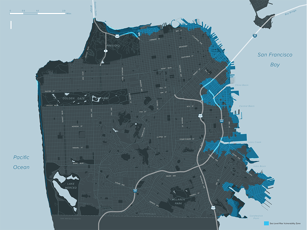
In addition to the broader Hazards and Climate Resilience Plan, San Francisco is working to understand the city’s vulnerability to the threat of sea level rise specifically. The Sea Level Rise exposure analysis completed in 2017 left no question that San Francisco’s lower-lying shoreline areas are exposed to flood waters in relatively near-term water-level scenarios. The Sea Level Rise Vulnerability and Consequences Assessment, to be completed in 2019, will provide information to decision-makers on the level of vulnerability of public assets to prioritize adaptation strategies.
The City has already adopted technical guidance for incorporating sea level rise into capital planning. Approved by the Capital Planning Committee in 2014 and currently undergoing an update, this guidance establishes a consistent review, planning, and implementation process for projects in the Sea Level Rise Vulnerability Zone. Departments are expected to identify and map project sites to check whether they fall within the Vulnerability Zone, fill out a checklist for all projects over $5 million funded within the next 10 years, and submit for review by the Chair of the Capital Planning Committee and the City Engineer.
Preliminary planning in areas known to be vulnerable to sea level rise is beginning. In May 2018, the Resilient by Design Bay Area Challenge launched design concepts for nine sites including the Islais Creek area in San Francisco. The design developed by the BIG+Sherwood team includes a restored creek with public spaces and recreational amenities, as well as industrial zones clustered in a jobs and logistics hub. Building on this work, in 2019 the Planning Department and Municipal Transportation Agency will collaborate to develop a Southeast Mobility Adaptation Strategy, funded by a CalTrans grant. This strategy will build adaptation scenarios to lay the groundwork for a resilient, safe, and reliable multimodal transportation system for projected population and job growth.
Planning for sea level rise is also underway on the west side of the city. The 2012 Ocean Beach Master Plan (OBMP), led by SPUR, involved federal, state, and local agencies in the development of a sustainable and resilient long-term vision for Ocean Beach. The 3.5-mile stretch of Ocean Beach is home to rugged coast, a national park, popular urban open space, and the site of some major infrastructure assets. The OBMP presents recommendations for the management and protection of Ocean Beach in the context of climate-induced sea level rise and severe erosion. It includes six Key Moves over a horizon of several decades. Current efforts include the removal of the Great Highway between Sloat and Skyline Boulevard under Key Move 1 and the introduction of a coastal protection, restoration, and access system under Key Move 2.
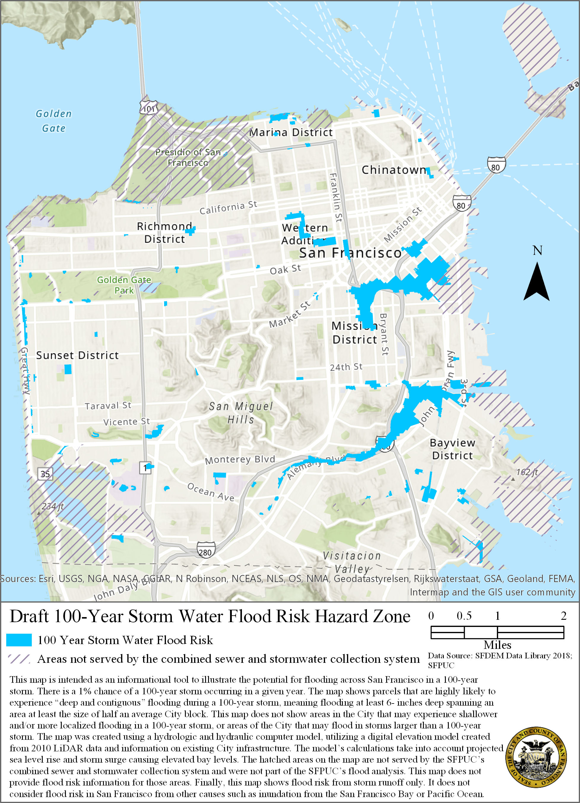
Sea level rise is not the only driver of our flood risks. Storm water also poses a threat, particularly during extreme precipitation events as runoff follows historic waterways and can result in flooding and sometimes property damage. As this type of flooding is not captured by our sea level rise maps or the Federal Emergency Management Agency’s floodplain maps, the SFPUC has developed a 100-Year Storm Flood Risk Map that shows areas of San Francisco where significant flooding from storm runoff is highly likely to occur during a 100-year storm. The purpose of the map is to inform existing and future property owners about flood risk on their properties and promote resilience.