|
Project Name |
Description |
|---|---|
|
OCII - Mission Bay |
Currently, maintenance of Mission Bay’s completed parks is funded by CFD #5. Once fully constructed, revenue generated by CFD #5 is insufficient to maintain the park system at full build out. As a result, there may be limited funds available for capital improvements to the parks as they age and require on-going improvements. |
|
OCII - Transbay |
Revenues from the Transbay CFD are projected to be insufficient to cover maintenance, security, and property management costs associated with a 2.5-acre under-ramp park located under the Salesforce Transit Center. The Transbay Joint Powers Authority, the principal landowner of the park, has selected the East Cut Community Benefits District (ECCBD) to operate the park, including fundraising for operating funds. |
|
OCII - Shipyard/Candlestick |
Funding sources need to be identified for Shipyard/Candlestick which is planned to include an arts center, eight acres of community facilities parcels, Building 101 upgrades, an additional fire station, and a school site. |
|
Planning - Racial and Social Equity |
Consistent with Mayor Breed’s mandates to achieve a diverse, equitable and inclusive city and to generate greater equitable outcomes in the provision of city services and the use of city funds, the Planning Department proactively works to advance racial and social equity through the following efforts:
|
|
Planning - Environmental Justice Framework |
The Environmental Justice Framework is being developed by the Planning Department and other City agencies to set clear goals and priorities to advance health in communities of color and low-income communities that face higher pollution and other health risks. These priorities are being developed in collaboration with communities most impacted by environmental justice, and will be spelled out in the forthcoming Environmental Justice Framework and related General Plan policies. California Senate Bill 1000 requires that cities and counties adopt policies in their General Plan to address environmental justice. Further, resolutions by the San Francisco Planning Commission and the Historic Preservation Commission “direct the Department to amend the General Plan to incorporate policies that explicitly prioritize racial and social equity for American Indian communities, Black communities, and communities of color.” The Environmental Justice Framework is expected for adoption in early 2023. |
|
Planning - SF Railyards Project |
The SF Railyards Project envisions the Caltrain railyards at 4th and King as a mixed-use neighborhood with a new underground rail station, added Caltrain service and new public spaces. The Planning Department is working with Caltrain and the landowner to identify potential track layouts and development concepts for the SF Railyards site. Combined with projects like the Downtown Rail Extension (DTX) and the Pennsylvania Avenue Extension, the SF Railyards project can create housing, connect communities, and increase resiliency. The Planning Department expects to partner with Caltrain and the landowner on a future development agreement at the Railyards site. |
|
Planning - Pennsylvania Avenue Extension |
In 2018, the Mayor and Board of Supervisors adopted the Pennsylvania Avenue Extension (PAX) as the preferred rail alignment to connect the 4th and King Station to the Bay Area and state. Coordinated with the SF Railyards Project, the PAX can stitch together neighborhoods divided by rail infrastructure, add acres to the public realm, and avoid significant wait times at the rail crossing with 16th Street, a major transit and emergency route. The SFCTA completed a project initiation report in 2022 and is expected to advance the project to environmental review by 2024. The Planning Department will continue in its role as urban designer and lead convener of the PAX, SF Railyards, and related projects. |
|
Planning - Civic Center Public Realm |
The Civic Center Public Realm Plan sets forth a 100-year vision to implement community-supported capital improvements that will address the inequities of access to open space, amenities, and emergency response areas for some of San Francisco’s most vulnerable populations. A collaboration between eight City agencies, the Plan creates a roadmap for continued investment in the area through capital upgrades, ensuring Civic Center’s streets, plazas, and other public spaces continue to serve existing neighborhoods and adjacent new development. |
|
Planning - Tenderloin Streetscape Plan |
The Tenderloin Streetscape Plan is a component of the Tenderloin Community Action Plan (Action Plan). The Action Plan’s collective vision includes streets reconfigured to provide safe, pleasant and usable open space to compensate for the under-supply of parks, playgrounds, gathering spaces and greenery in the Tenderloin neighborhood. The Plan, led by the Planning Department will work with the community partners and city agencies to develop conceptual designs for streets, develop a streetscape plan, complete environmental review and develop relevant materials for approvals. |
|
Port – Embarcadero Historic Piers |
Many of the Port’s one-of-a-kind facilities in the Embarcadero Historic District need repair and remain closed to the public. In the fall of 2018, the Port of San Francisco issued a Request for Interest (RFI) to gather feedback about how to rehabilitate and preserve 16 historic facilities in need of significant investment. Through the RFI, the Port sought creative ideas on how these historic piers can be accessible, resilient, and best used. The Port received 52 unique responses to the RFI. Based upon the favorable input received from the RFI, the Port Commission authorized staff to release a Request for Proposals (RFP) to seek development partners to invest and activate the piers with a mix of uses including revenue generating uses (commercial and production, distribution, and repair uses) and public-oriented uses (public access, retail, restaurants, cultural, and community space). Historic pier rehabilitation provides opportunities for economic, cultural, and public improvements and attracts investments for vital capital and seismic upgrades. The Port identified three sets of piers to advance in development first. This included Piers 38 and 40 (South Beach Piers), Piers 19-23, 29-31 (Northern Waterfront Piers) and eventually Pier 26 & 28. The Port released the Piers 38 and 40 RFP in January 2020 and received two responses in advance of the due date. The Port used a scoring panel to rank the responses and in August 2020 the Port Commission authorized staff to negotiate an Exclusive Negotiating Agreement with Pacific Waterfront Partners. The proposal includes a mix of uses including water recreation facilities and suite of commercial maritime uses. The proposal also includes improvements support the Port and City’s resilience program including improvements to the seawall and design features to address sea level rise. Port staff anticipates that negotiations, entitlements and design for the project could take 24 to 36 months and construction could begin in 2024 or 2025. Due to the COVID-19, Port staff expect to evaluate potentially releasing the next RFP for the northern waterfront piers in 2023. |
|
Port – Conditional Seismic Costs |
Renewal work on the Port’s piers for a project that changes the use or substantially increases the occupancy or size of the facility may require a seismic upgrade to comply with code. The seismic cost estimate in the Port’s Ten-Year Capital Plan represents a conservative approach in terms of the total potential cost for repair work. Conditional seismic work on these facilities are estimated to cost approximately $640 million. |
|
TIDA – Public Buildings Renovations |
TICD has the option under the DDA to enter into long-term master leases for Building 1 and Hangars 2 and 3 on Treasure Island and the Senior Officers’ Quarters Historic District on Yerba Buena Island. Under the master leases, TIDA anticipates assigning responsibility to the lessee for the renewal, improvement, and preservation of these facilities. Depending upon the extent of work required, however, supplemental investment may be required to preserve the buildings and facilitate their reuse. TIDA will be performing condition and needs assessments to inform leasing negotiations and future capital planning efforts. Another historic building within TIDA’s holdings is known as the Torpedo House, which is also listed on the Federal Register of Historic Places. Currently, the building is a bare concrete structural shell. As a mitigation for demolishing a historic Coast Guard structure as part of the TIMMA-managed eastbound on- and off-ramp project, the project will replace the roof, windows and doors of the Torpedo House. Adjacent to the site, Caltrans has developed a new public space known as the Bimla Rhinehart Vista Point. Instead of imploding the last pier of the former eastern span of the Bay Bridge (Pier E-2), Caltrans elected to keep it, cut it down to lower its elevation, and construct a land bridge. The finished site includes public picnic tables, seating, and offers a vantage point on the Bay and the new Bay Bridge span. It is likely that the Phase II improvements to the Bimla Rhinehart Vista Point will be combined with the improvements to the Torpedo House as a single construction contract managed by BATA/MTC and the SFCTA on behalf of TIDA. The Vista Point should provide a complimentary attraction to the future reuse of the Torpedo House. |
|
TIDA – Navy Structures to Remain |
In addition to the public buildings discussed above, a limited number of other existing structures – the former Navy chapel, gymnasium, and Pier 1 – will be preserved through development. Pier 1 is to be programmed to be a public access/recreational space and the gymnasium will continue to be a recreational facility for island residents. As with the other public buildings, TIDA will be making condition and needs assessments of each of these facilities to inform future capital planning efforts. |
|
TIDA – School Site |
While the Naval Station Treasure Island was operational, the San Francisco Unified School District (SFUSD) operated an elementary school on the base. Under the DDA and related documents, the site of former school was to be made available to SFUSD to develop a K-5 or K-8 facility. TICD is obligated to make a payment of $5 million towards the development of the new school, and TIDA has been in discussion with SFUSD facilities staff regarding the potential programming, funding, and schedule for a new school on Treasure Island. The SFUSD have leased a portion of the site for training and administrative purposes prior to taking title to the site and the development of the new school. |
|
Multiple Departments – Alemany Farmers’ Market |
The Alemany Farmers’ Market was founded in 1943 and is a vitally important option for San Franciscans to access affordable, healthy produce. It occupies a 3.5-acre parcel that is unused five days a week and is surrounded by several other publicly owned parcels. The Market is under the jurisdiction of the Real Estate Division, and the City is currently undergoing an interagency effort to envision potential future land use opportunities at the site, including affordable housing. This effort will include planning and design work to ensure the continued operation of the Market, additional infrastructure to accommodate pedestrian and bicycle access to the site, feasibility studies, and community engagement with surrounding neighborhoods. |
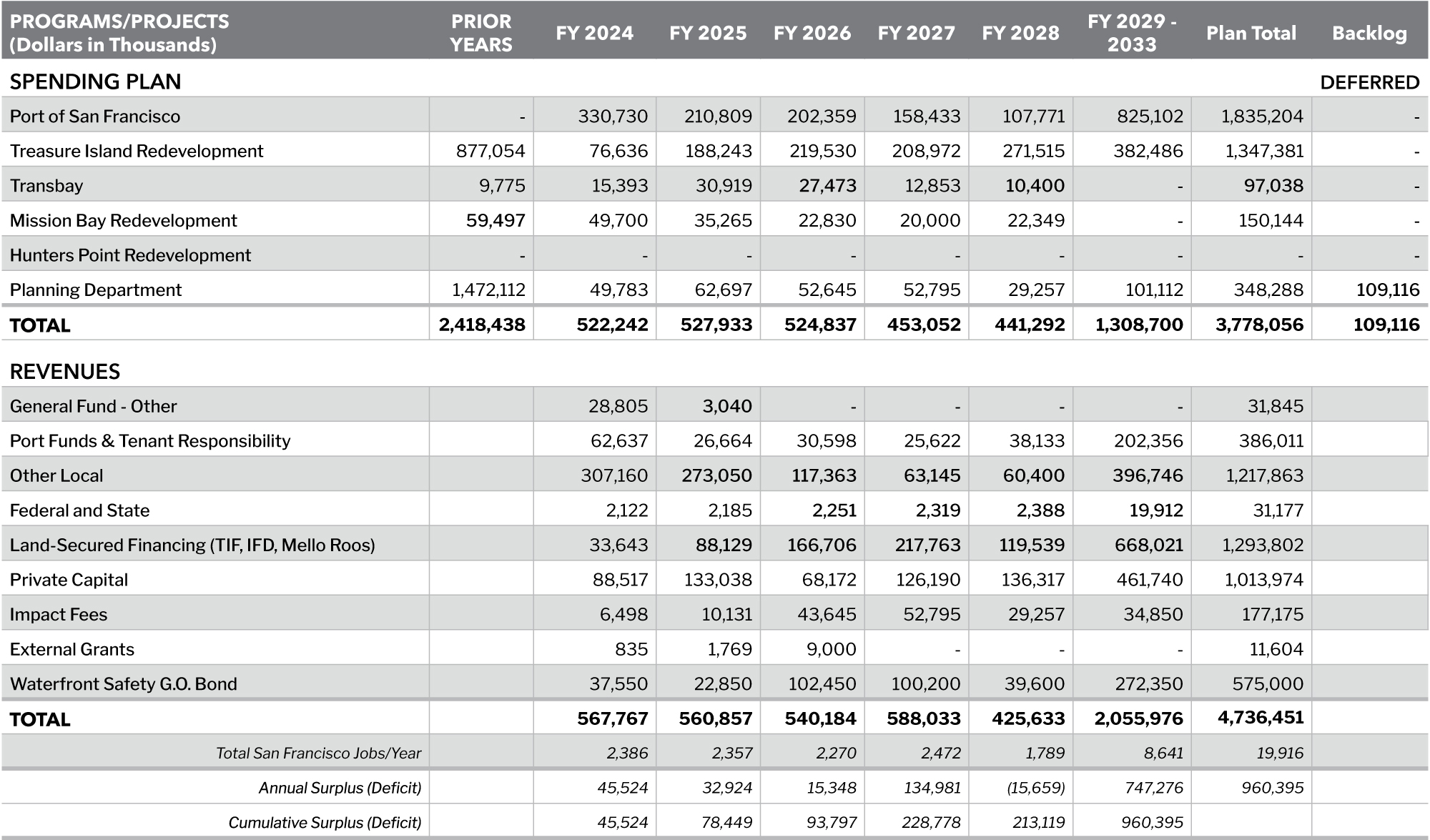
Table 7.2 - ECONOMIC + NEIGHBORHOOD DEVELOPMENT FINANCIAL SUMMARY