CAO: Office of the City Administrator
DT: Department of Technology
MOD: Mayor’s Office on Disability
MOS: Moscone Convention Center
PW: Public Works
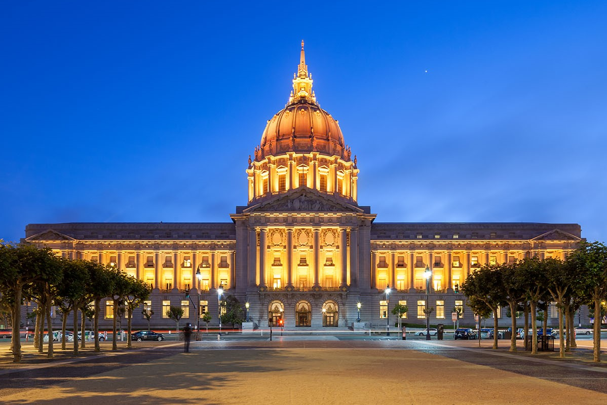
San Francisco City Hall
The delivery of local government services relies on careful planning, smooth internal operations, and performance monitoring. Many of these responsibilities falls under the Office of the City Administrator (CAO). The CAO is comprised of a broad array of departments, divisions, programs, and offices, and is committed to increasing San Francisco’s safety and resilience through effective government services. Day in and day out, CAO’s operations help the wheels of government to turn.
The General Government Service Area encompasses the capital needs that pertain to the operations of CAO departments; projects delivered for client departments by CAO are captured in the Plan’s other Service Areas.
Overview
Office of the City Administrator
The Office of the City Administrator delivers a wide range of capital-related services, including the maintenance and management of City-owned buildings, real estate, capital planning, and technology services. These operations support the service delivery of other City departments.
Public Works
Public Works (PW) takes care of San Francisco's streets, infrastructure, and public buildings. Divisions under the City Architect relate to facility design, construction, maintenance, and repair. The Bureau of Building Repair provides construction, repair, remodeling, and management services to City-owned facilities. The Building, Design, and Construction and Project Management divisions provide facility programming, architectural design, planning, conceptual design, and construction management services. PW programs that address San Francisco’s horizontal infrastructure are discussed in theInfrastructure and Streets Chapter.
Real Estate
The Real Estate Division (RED) within CAO manages over five million square feet of office space and other civic facilities that support the operations of city departments. RED is responsible for the acquisition of all real property required for City purposes, the sale of surplus real property owned by the City, and the leasing of property required by various City departments. RED also manages facility operations at the Alemany Farmers’ and Flea Markets and Yerba Buena Gardens. Additionally, RED is the property manager for City Hall, 1 South Van Ness, 25 Van Ness, 49 South Van Ness, 1650 Mission Street, the Hall of Justice, the Public Safety Building, and 555 7th Street.
Technology
The Department of Technology (DT) is San Francisco’s information and technology services organization, providing leadership, policy direction, and technical support for technology and information solutions. DT has both internal and public-facing initiatives.
The department manages the City’s network operations and data centers. It also maintains the City’s fiber optics network, radio system, digital security, and other vital systems. DT serves the public through efforts such as the Fiber to Housing program, which provides free broadband internet to residents of affordable housing, and the delivery of SFGovTV.
Moscone Convention Center
Covering more than 20 acres on three adjacent blocks, the City-owned Moscone Center is the premier destination for conventions, meetings, and tradeshows. It is one of the nation’s few LEED Platinum-certified convention centers, offering over one million square feet of exhibition and meeting space and more than 25,000 square feet of outdoor terraces for receptions.
Conventions and exhibitions are responsible for generating approximately 20% of the $10 billion total tourism spending in San Francisco.
Mayor’s Office on Disability
The Mayor’s Office on Disability (MOD) ensures accessibility within all City departments’ initiatives. The mission of MOD is to ensure that every program, service, benefit, activity, and facility operated or funded by the City is fully accessible to, and useable by, people with disabilities. Historically, MOD oversaw the implementation of the highest-priority projects in the City’s ADA Transition Plans for facilities and public right-of-way barrier removals. Today, as part of the City’s ongoing obligation to carry out architectural and programmatic self-assessment, MOD helps coordinate department-level capital funding requests for barrier removal in these areas.
Currently, maintenance of Mission Bay’s completed parks is funded by CFD #5. Once fully constructed, revenue generated by CFD #5 is insufficient to maintain the park system at full build out. The Recreation and Parks Department and Port of San Francisco assumed management of the Mission Bay park system in 2023. As a result, if CFD #5 funds are insufficient, General Funds may be available for capital improvements to the parks as they age and require ongoing improvements.
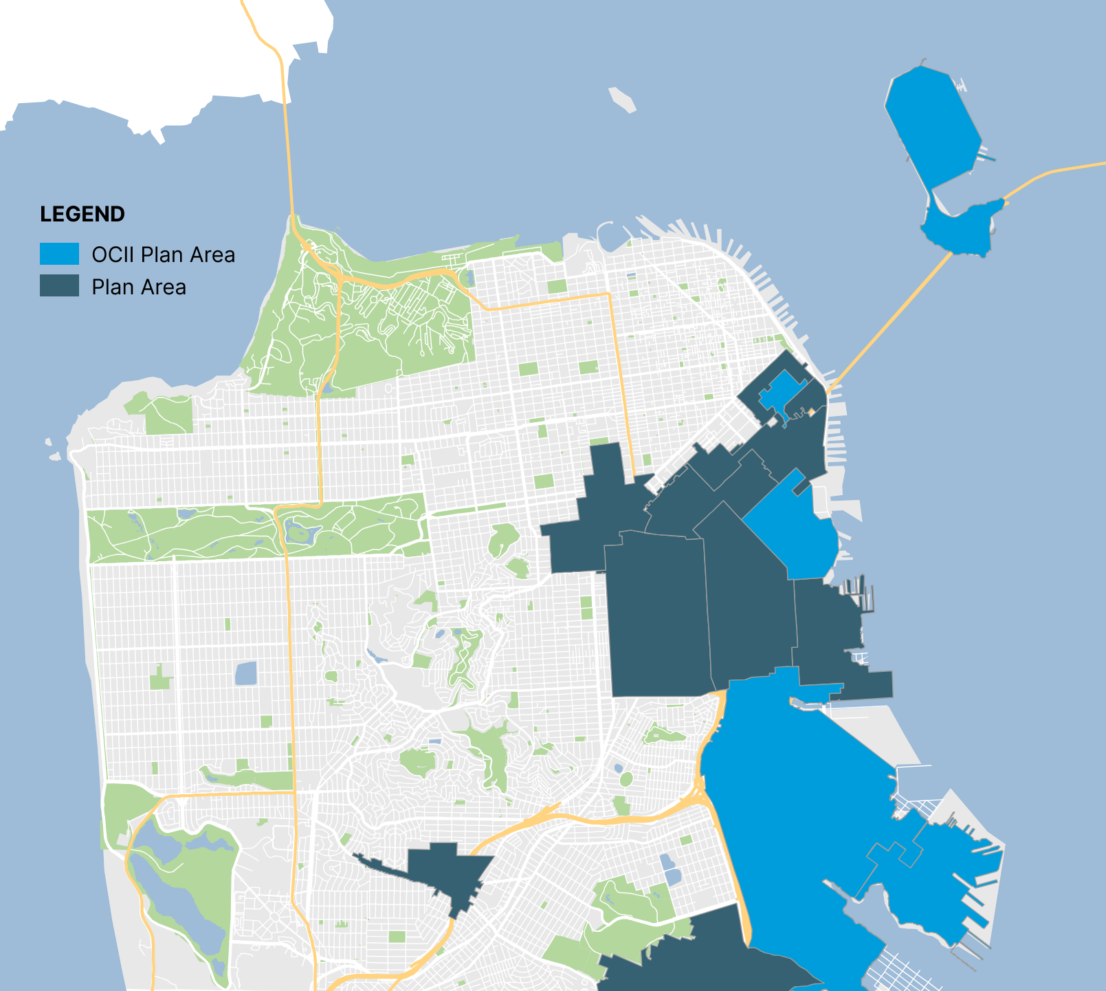
OCII – Transbay
Revenues from the Transbay CFD are projected to be insufficient to cover maintenance, security, and property management costs associated with a 2.5-acre under-ramp park located under the Salesforce Transit Center. The Transbay Joint Powers Authority, the principal landowner of the park, has selected the East Cut Community Benefits District (ECCBD) to operate the park, including fundraising for operating funds.
OCII – Shipyard / Candlestick
Funding sources need to be identified for Shipyard / Candlestick which is planned to include an arts center, eight acres of community facilities parcels, Building 101 upgrades, an additional fire station, and a school site.
Planning – Expanding Housing Choices (Housing Element Rezoning)
Expanding Housing Choice (Housing Element Zoning Program) is a state-mandated implementation action identified in the certified 2022 Housing Element. The program will amend zoning policies in the Housing Opportunity Areas, largely in the western and northern parts of the city, to increase capacity for multi-family housing to satisfy the City’s Regional Housing Needs Allocation (RHNA) gap of 36,200 housing units. The City of San Francisco has until January 2026 to complete the rezoning effort.
San Francisco is required to add housing – and in particular, affordable housing – in the Housing Opportunity Areas to meet state and federal laws on Affirmatively Furthering Fair Housing, which require that we work toward more racially and socially inclusive communities and take actions to undo historic patterns of racial and economic segregation. These Housing Opportunity Areas are areas designated by the state as having better access to economic and educational opportunities and lower exposure to environmental hazards, which are all shown to result in better outcomes for low- and moderate-income residents. In parallel with the rezoning program, the City is working to realize Housing Element Implementing Program 1.2.1, which sets a target of building 25-50% of the City’s new permanently affordable housing units in the Housing Opportunity Areas.
Most rezoned areas will allow midrise housing (65’-85’ tall, or 6-8 stories), with higher height limits considered in selected areas. In the areas surrounding these transit corridors and key sites, parcels will be permitted to build fourplexes and 6-plexes under adopted and pending legislation. This increased density will bring with it an increased public infrastructure need, which will also be addressed by the rezoning program.
Planning – SF Railyards Project
The SF Railyards Project envisions the Caltrain railyards at 4th and King Streets as a mixed-use neighborhood with a new underground rail station, added Caltrain service and new public spaces. The Planning Department is working with Caltrain and the landowner to identify potential track layouts and development concepts for the SF Railyards site. Combined with projects like the Portal (a.k.a. the Downtown Rail Extension or DTX) and the Pennsylvania Avenue Extension (PAX), the SF Railyards project can create housing, connect communities, and increase resiliency. The Planning Department anticipates partnering with Caltrain and the landowner on a future development agreement at the Railyards site.
Planning – Freedom West Development Project
Freedom West is an existing, 382-unit cooperative housing site in the Western Addition, directly south of Jefferson Square Park and west of Civic Center. The project sponsor, a joint venture between a developer and the co-op residents, is proposing a 2,500-unit mixed-use development. It would include replacement co-op housing, additional affordable housing, market rate housing, ground floor commercial and community spaces, and potentially a hotel. New publicly accessible and private open spaces would serve the residents and broader community. The Planning Department is currently collaborating with the developer on the design standards document and other pre-approvals work.
Planning – Pennsylvania Avenue Extension
In 2018, the Mayor and Board of Supervisors adopted the Pennsylvania Avenue Extension (PAX) as the preferred rail alignment to connect the 4th and King Station to the Bay Area and state. Coordinated with the SF Railyards Project, the PAX can stitch together neighborhoods divided by rail infrastructure, add acres to the public realm, and avoid significant wait times at the rail crossing with 16th Street, a major transit and emergency route. The SFCTA completed a project initiation report in 2022 and launched a pre-environmental study in 2024. The Planning Department will continue in its role as urban designer and lead convener of the PAX, SF Railyards, and related projects.
Planning – Civic Center Public Realm
The Civic Center Public Realm Plan sets forth a 100-year vision to implement community-supported capital improvements that will address the inequities of access to open space, amenities, and emergency response areas for some of San Francisco’s most vulnerable populations. A collaboration between eight City agencies, the Plan creates a roadmap for continued investment in the area through capital upgrades, ensuring Civic Center’s streets, plazas, and other public spaces continue to serve existing neighborhoods and adjacent new development. Known public realm improvement priorities include Civic Center Plaza and associated subterranean facilities, Fulton Mall, UN Plaza, War Memorial Gateway, and pedestrian safety improvements.
Planning – Tenderloin Community Action Plan
The Tenderloin Streetscape Plan is a component of the Tenderloin Community Action Plan (Action Plan). The Action Plan’s collective vision includes streets reconfigured to provide safe, pleasant and usable open space to compensate for the under-supply of parks, playgrounds, gathering spaces and greenery in the Tenderloin neighborhood. The Plan, led by the Planning Department will work with the community partners and city agencies to develop conceptual designs for streets, develop a streetscape plan, complete environmental review and develop relevant materials for approvals.
Planning – 749 Toland Development Agreement Project
A proposed development agreement project at 749 Toland would include two new commercial buildings. Each building would be designed to provide flexibility for potential future PDR tenants with built in circulation, ramping, and parking. New parking, bike parking and car-share spaces will be provided. The Project will include also incorporate streetscape improvements with new ADA ramps, sidewalks, street trees, bicycle parking. and loading. Planning and OEWD are currently negotiating the community benefits package with the project sponsor.
TIDA – Navy Structures to Remain
In addition to the public buildings discussed above, a limited number of other existing structures – the former Navy chapel, gymnasium, and Pier 1 – will be preserved through development. Pier 1 is to be programmed to be a public access/recreational space and the gymnasium will continue to be a recreational facility for island residents. As with the other public buildings, TIDA will be making condition and needs assessments of each of these facilities to inform future capital planning efforts.
TIDA – School Site
While the Naval Station Treasure Island was operational, the San Francisco Unified School District (SFUSD) operated an elementary school on the base. Under the DDA and related documents, the site of former school was to be made available to SFUSD to develop a K-5 or K-8 facility. TICD is obligated to make a payment of $5 million towards the development of the new school, and TIDA has been in discussion with SFUSD facilities staff regarding the potential programming, funding, and schedule for a new school on Treasure Island. The SFUSD have leased a portion of the site for training and administrative purposes prior to taking title to the site and the development of the new school.
TIDA – Treasure Island Road (Bus Queue Jump Lane) Make Ready Project
In accordance with the approved EIR, a bus queue jump lane is required on Treasure Island on the SF bound direction from the intersection of Treasure Island Road and Macalla Road on one end to the on ramp to the Bay Bridge. This is required when TIMMA determines that the MUNI 25 level of service requires it. Currently, the Treasure Island Road is closed to the public due to ongoing construction of the Westside Bridges Project implemented by the SFCTA. Both SFCTA and TIDA believe this presents a limited opportunity to install the necessary improvement and create the right-of-way and condition to implement the required bus queue jump lane. The necessary improvement primarily includes the installation of a retaining wall up to 15 foot height on the east side of TI Road for approximately 1300 linear feet.
The estimated cost for the Treasure Island Road Bus Queue Jump Lane Make Ready Project is approximately $3.5 million and is currently unfunded.
SFPUC/SFFD – Treasure Island Supplemental Fire Water Pump Station
As part of the City (PUC and SFFD) obligations to the Treasure Island development project, the City (PUC) will design and construct a supplemental fire water pump station near Pier 1 as shown in the to be permitted Stage 2/3 TI Street Improvement Plan. TIDA's has engaged a consultant and estimated in 2020 with broad assumption that this proposed saltwater pump station will cost $18M. The proposed pump station will connect to the standpipe and hydrants system within Trade Winds Ave and Seven Seas Ave. The Master Developer is responsible for designing and installing the standpipe and hydrants system. Stage 1 of the standpipe and hydrants systems have been installed.
The estimated cost for the Treasure Island Supplemental Fire Water Pump Station is approximately $18.0 million and is currently unfunded.
Port – Conditional Seismic Costs
Renewal work on the Port’s piers for a project that changes the use or substantially increases the occupancy or size of the facility may require a seismic upgrade to comply with code. The seismic cost estimate in the Port’s Ten-Year Capital Plan represents a conservative approach in terms of the total potential cost for repair work.
Conditional seismic work on these facilities are estimated to cost approximately $640 million.
Multiple Departments – Alemany Farmers’ Market
The Alemany Farmers’ Market was founded in 1943 and is a vitally important option for San Franciscans to access affordable, healthy produce. It occupies a 3.5-acre parcel that is unused five days a week and is surrounded by several other publicly owned parcels. The Market is under the jurisdiction of the Real Estate Division, and the City is currently undergoing an interagency effort to envision potential future land use opportunities at the site, including affordable housing. This effort will include planning and design work to ensure the continued operation of the Market, additional infrastructure to accommodate pedestrian and bicycle access to the site, feasibility studies, and community engagement with surrounding neighborhoods.
Balboa Park is located in southern San Francisco and provides several amenities that can be leveraged to promote a more livable neighborhood. The area includes the Ocean Avenue campus of the City College of San Francisco, the Ocean Avenue Neighborhood Commercial District, Balboa Park, and the Balboa Park BART station. The area is home to the Balboa Park Reservoir, where 1,100 units of housing are slated for development.
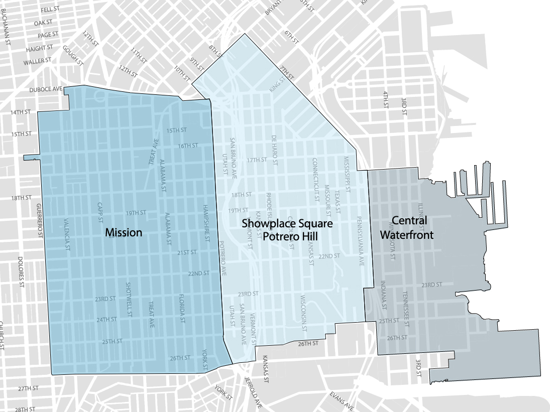
Eastern Neighborhoods
The Eastern Neighborhoods Area Plan consists of several smaller neighborhoods, including the Mission, Showplace Square/Potrero Hill, and Central Waterfront. Much of the land use in the Eastern Neighborhoods was historically dedicated to industrial uses, and production, distribution, and repair. Over time, residential and commercial uses have grown. In 2010, population in the Eastern Neighborhoods Plan Area was 83,930. The Planning Department projects the population to reach 149,570 by 2040, an increase of 78%.
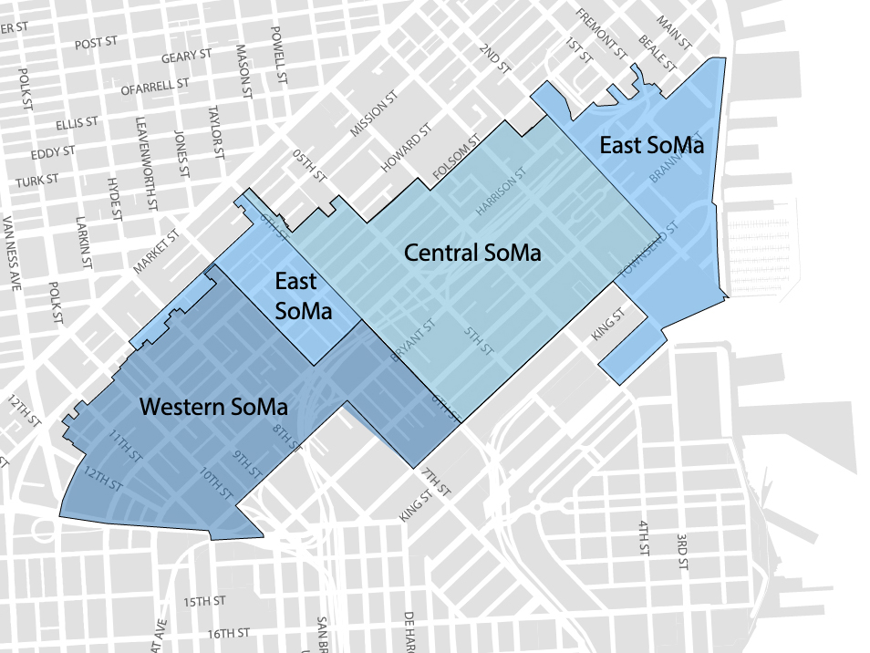
SoMa
SoMa includes three Area Plan geographies: Western SoMa, Central SoMa, and Eastern SoMa. The Central SoMa Plan is the most recently approved, enables the most significant amount of additional growth, and creates the greatest amount of potential revenue through new impact fees and the establishment of a CFD to pay for new infrastructure projects. The vision of the Central SoMa Plan is to create a social, economic, and environmentally sustainable neighborhood by 2040, with space for approximately 32,000 new jobs and 8,600 new housing units. The Plan is expected to result in up to $2.2 billion in public benefits to serve critical needs of the neighborhood, including affordable housing, transportation, streets improvements, parks and recreation, schools, environmental sustainability, and community services. Funding for these projects will be derived from a combination of new and existing impact fees, CFD special tax revenues, direct provision by developers, and various other sources of funding. These funds will be received as development occurs in the Plan Area over the next 25 years.
Market Octavia
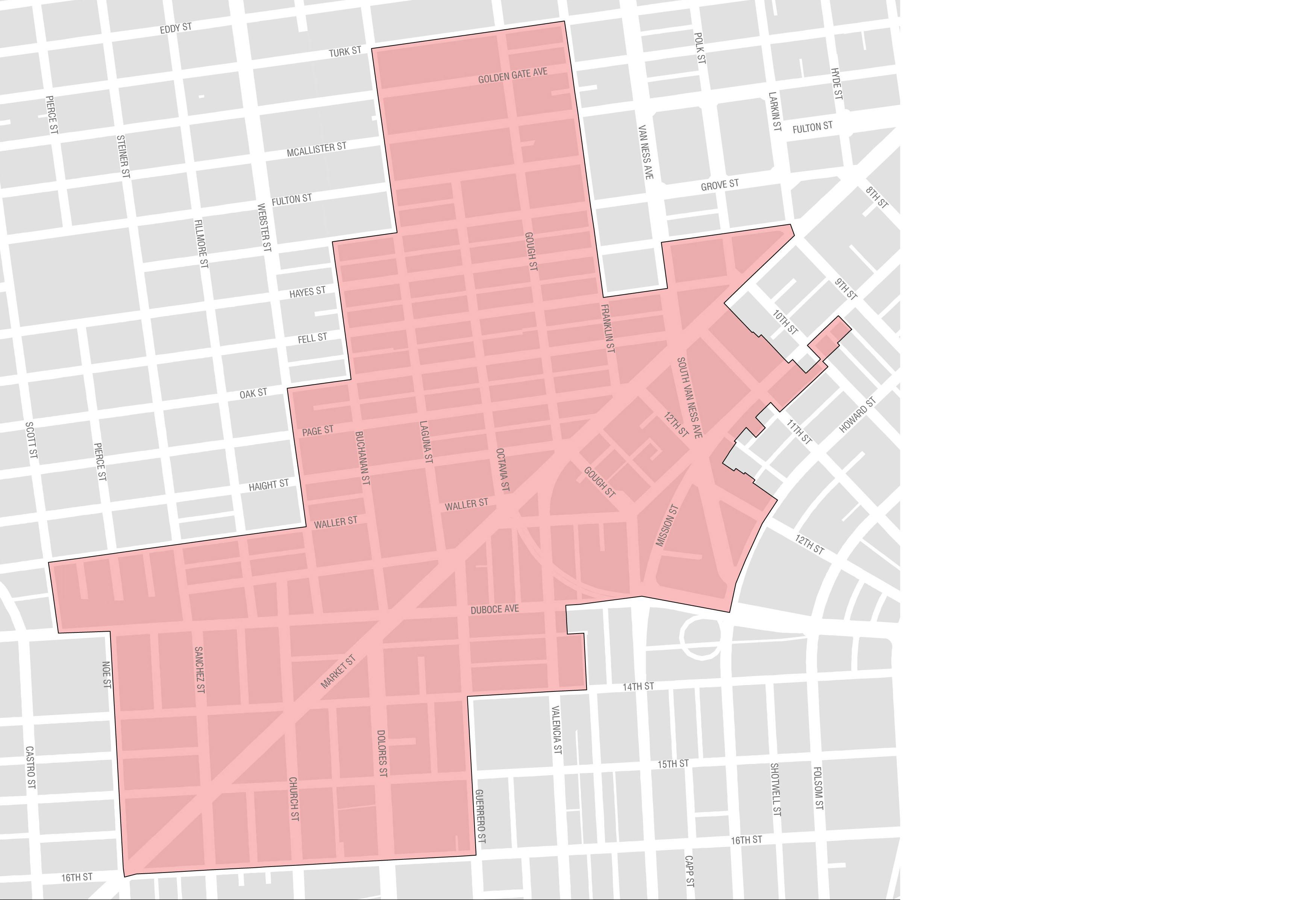
Market Octavia is located just west of the Civic Center, where governmental and cultural institutions attract visitors both day and night. Its pattern of streets and alleys make it walkable and bikeable. More than a dozen transit lines cross the neighborhood, including all of the city’s core streetcar lines. It is accessible from the entire Bay Area by BART and the regional freeway system.
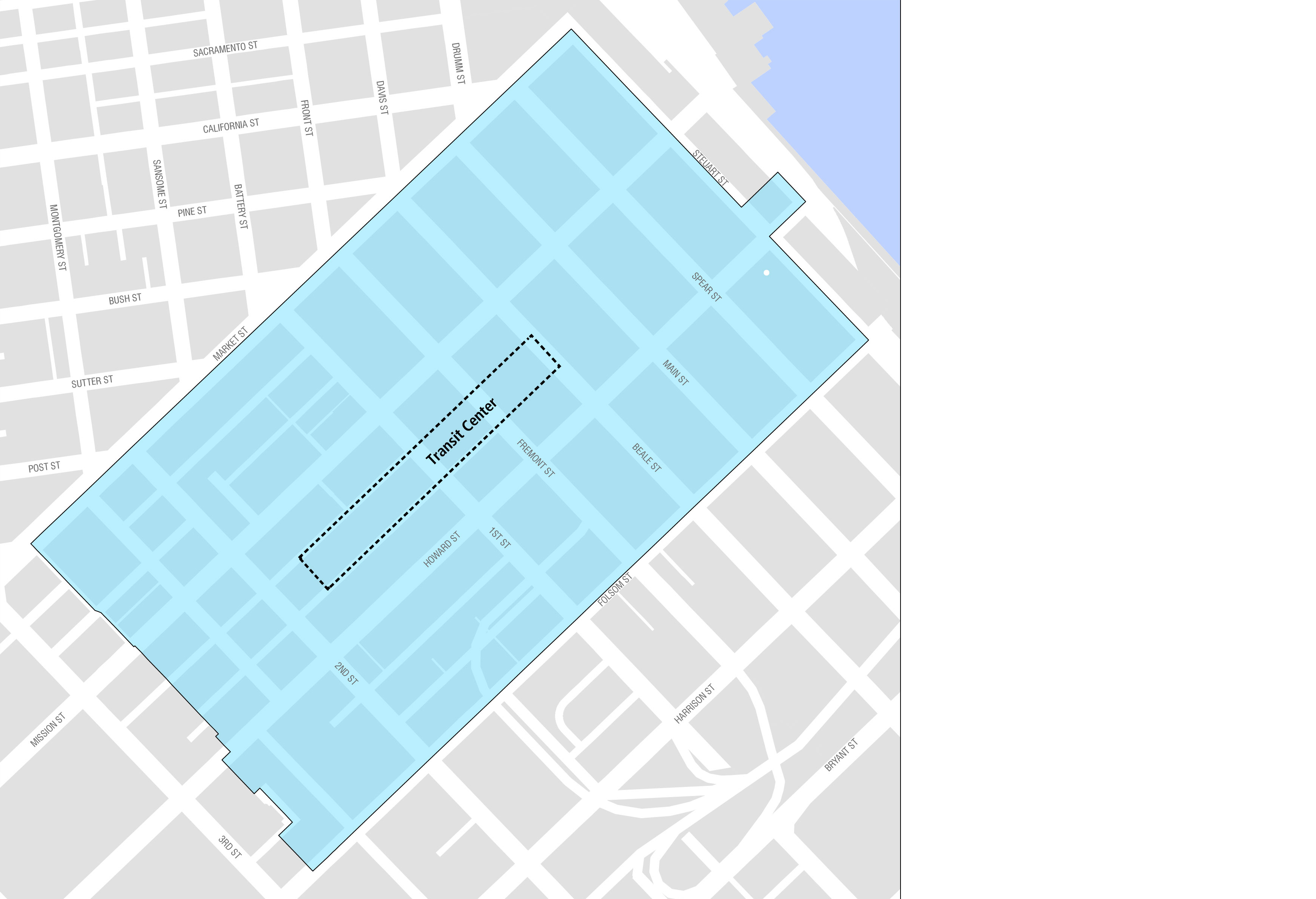
Transit Center
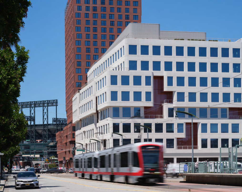
The Transit Center District Plan was adopted in 2012 to provide infrastructure improvements in conjunction with the opening of the Salesforce Transit Center. The Salesforce Transit Center is a $2.2 billion transportation hub that replaces the old Transbay Terminal and connects 11 regional transportation providers to downtown San Francisco. In addition to passengers arriving at the Transit Center, the Plan also includes several commercial developments.
Rincon Hill
Rincon Hill is located in the northeast section of San Francisco, close to the Bay Bridge. Historically the neighborhood has contained many vacant lots and underutilized parcels, which have been rezoned for housing. Additionally, new parcels were opened up for development after the Embarcadero Freeway was demolished in 1991. Rincon Hill is accessible to many transit lines including the Muni Metro system and BART at Embarcadero station, which make Rincon Hill a strategic area to construct new housing in San Francisco.
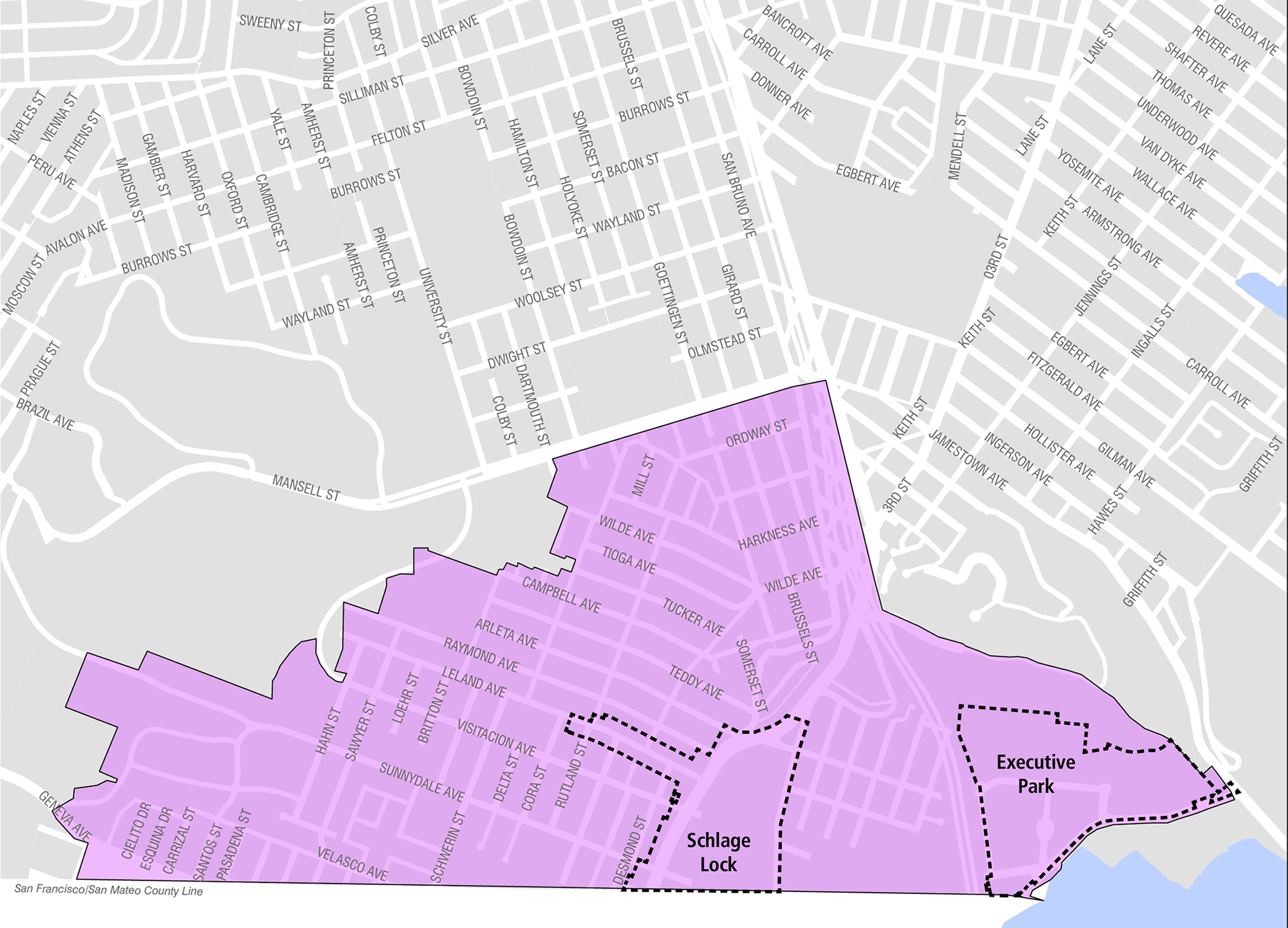
Visitacion Valley
Visitacion Valley is located in southeast San Francisco, near the Brisbane border. In 1999, the Schlage Lock company decided to close its factory located in the area. The now-vacant site presents opportunities for new uses. New developments in the area are expected to produce a net increase of 4,800 housing units, 140,000 square feet of commercial/retail space, and 75,000 square feet of community space over at least ten years. An impact fee was implemented in 2005 for Visitacion Valley in anticipation of higher density development planned for Executive Park, the sub-area immediately east of the 101 Highway, Sunnydale HOPE SF, and Schlage Lock.
The Potrero Terrace and Annex project is a phased, master-planned new construction development consisting of the demolition of the existing 619 public housing units on the property and the construction of up to 1,700 new units, including one-for-one replacement of the existing public housing units, additional affordable rental units, and market-rate rental and for-sale units. The project will also feature up to 15,000 square feet of neighborhood-serving retail space, approximately 30,000 square feet of community space, approximately 3.5 acres of new open spaces, and a reconfigured street network. The multi-phase redevelopment plan will be completed over the next 10-12 years.
The Phase II infrastructure scope consists of rough grading, major utility extensions, and installation of new public streets and sidewalks. The new housing parcels are planned as one affordable housing building with approximately 115 units and one market rate building with up to 160 units. Existing streets segments of Wisconsin Street, 25th Street, and 26th Street will be reconstructed and regraded; a new segment of Arkansas Street will feature head-in parking on the eastern side and parallel parking spaces on the west, and streetscape will be designed with new sidewalks, curb ramps, and bulb-outs.
HOPE SF – Sunnydale and Velasco
The Sunnydale and Velasco project is a phased, master-planned new construction development that will demolish the existing 775 public housing units on the property and construct up to 1,700 new units, including one-for-one replacement of the existing public housing units, affordable rental units, and market-rate and affordable for-sale units. The project will also provide up to 16,200 square feet of retail space, up to 46,300 square feet of community service, and educational facilities. Approximately 11 acres of new parks and recreation spaces and approximately 12 acres of new and reconfigured streets will be built as part of the project. The multi-phase redevelopment plan will be completed over the next 12-15 years.
Infrastructure improvements include construction of three new streets, relocation of existing electrical power poles and overhead lines, new underground utilities including a combined sewer system and new electrical switchgear, lighting and bio-retention curb bulb extensions, a new pedestrian mews, and demolition and abatement of 120 existing units in 16 buildings.
OCII Mission Bay – Parks and Open Space
The construction of nine additional parks in Mission Bay is anticipated over the next four years. Remaining parks include the remaining segments of the Mission Creek park loop, remaining segments of the Mission Bay Commons, and two active recreation parks near Owens Street in Mission Bay South.
The cost of future OCII Mission Bay Parks and Open Space is approximately $72.4 million through FY2035.
OCII Mission Bay – Streetscape and Underground Utilities
Additional roadways, underground utilities and pedestrian and bicycle improvements are needed to serve the new residential neighborhood and research district in the southern portion of Mission Bay. The remaining improvements will be constructed over the next two years.
The cost of future OCII Mission Bay Streetscape and Underground Utilities is approximately $4.8 million through FY2035.
OCII Mission Bay – Storm Water Treatment
The remaining required storm water treatment improvement in Mission Bay is located south of Mission Creek. This southern portion of Mission Bay will have a storm water treatment system separate from the combined sewer/storm water system found in the rest of the city to avoid additional burden on the Southeast Treatment Facility. Construction of a final storm water pump station is expected within the next two years.
The cost of future OCII Mission Bay Storm Water Treatment is approximately $8.4 million through FY2035.
OCII Transbay – Parks and Open Space
Two new Transbay parks are in development. The nearly 2.5-acre Under-Ramp Park (“URP”), located under the Salesforce Transit Center bus ramp and Fremont St. off-ramp from I-80 will include plazas, walking and bicycle paths, landscaping, sport courts, concessions, and a large dog park. Construction is expected to begin in 2026, with completion in 2028. As URP will be located on property owned by the TJPA and Caltrans, CCSF will not be responsible for maintaining the park. The 1-acre Block 3 park, located on a portion of the former Temporary Bus Terminal, will include landscaping, play areas, and gathering spaces. The park’s design was completed in early 2024 with construction anticipated to commence in summer 2024. OCII elected to delay construction of the park so that the interim activation on Transbay Blocks 3 and 4 known as “The Crossing” could continue its operations which serve as a stimulant to downtown activation. OCII is instead expediting the delivery of URP, which will bring further activation to the East Cut neighborhood and downtown. OCII is pausing development of Block 3 for at least 2 years until summer 2026. Upon the eventual completion of the Block 3 park, OCII will transfer the public space to the Recreation and Parks Department to own and operate.
The cost of design and construction for both parks is estimated at $91 million.
OCII - Hunters Point Shipyard Phase 1 Parks and Roads
Developer will complete roads for Hillside development by 2026 and construction of 7 acres of parks will occur between 2026-2030.
OCII – Candlestick Point Parks and Roads
Between 2025-2035 the developer will construct new roads for 3 phases of development, generally in the former footprint area of the Candlestick Stadium, which includes extension or improvements of existing roads such as Harney Way, Candlestick Park Drive, Arelious Walker Drive, Gilman, Carroll Ave, Donner, Egbert, Fitzgerald Griffith and Bill Walsh Way. Harney Way will include cycletrack and bus rapid transit facilities. Several new interior streets will be constructed as well to create the new Candlestick neighborhood grid. The Developer will construct the Willie Mays Park, Plaza, and Central Promenade during this period. The Developer will also construct a new outfall for stormwater discharge for the Candlestick area.
Roads and utility costs are estimated at $136 million for this construction period. An estimated $19 million dollars will be spent on three small scale parks.
Port – National Park Service Alcatraz Embarkation Site
The Alcatraz Project will activate the Pier 31 bulkhead with a plaza, café, and improved public restrooms and transform the Pier 33 bulkhead into a visitor-contact station. $7.5 million in repairs have been made to the facility’s substructure to prepare the site for the new tenants. Further investments in the site will be made through leases with the new ferry concessioner, Alcatraz Cruises, LLC (selected by the National Park Service through its competitive-bid process) and the Golden Gate National Parks Conservancy. These planned Alcatraz Embarkation Project is expected to be complete by November 2026.
The Port anticipates that the project will ultimately result in $43.8 million of investment in Piers 31-33.
Port – Pier 70 Waterfront Site
With Brookfield Properties, the Port’s development partner, the Pier 70 Project is planned to construct recreational and art programming along with housing and commercial development. Construction started in 2018 and the full build-out is estimated to be completed in 10-15 years. The project includes 6.5 acres of waterfront parks, playgrounds, and recreational uses; new housing units (including 30% below market-rate); restoration and reuse of currently deteriorating historic structures; new and renovated space for arts, cultural, small-scale manufacturing, local retail, and neighborhood services; up to 1.75 million square feet of new commercial and office space; and parking facilities and other transportation infrastructure.
This public-private partnership project is projected to cost $383 million in horizontal infrastructure improvements. A combination of land contributions, tax increment from an Infrastructure Financing District, and special taxes from a Community Facilities District will reimburse the developer for infrastructure costs.
Port – Seawall Lots 323 and 324
The Port Commission approved an agreement with TZK Broadway, LLC to improve Seawall Lots 323/324 and the nearby street stubs with a mixed-use development. This proposed development is planned to include the following: a four-story building with a 192-room hotel, a dinner-theater space featuring the historic “Spiegeltent”, and approximately 14,000 square feet of park space. Teatro ZinZanni will operate the dinner-theater. Due to COVID-19 disruption, implementation was delayed, and the project is expected to be complete by 2027.
The Port anticipates that this development will ultimately result in over $172 million of private capital being invested in this Port- owned vacant land parcel.
Port – Pier 30/32 and Seawall
Lot 330
The Port Commission endorsed a term sheet with Strada – Trammel Crow Properties to redevelop this site near Oracle Park. Project will include a projected 713 units of housing, of which 25 percent will be affordable, an aquatic center including a swimming pool, a retail market hall, approximately 375,000 square feet of office space with the potential for an additional 55,000 square feet of mezzanine space within the existing footprint of the building, a reconstructed pier, and seismic and sea level rise resilience improvements to the seawall and pier infrastructure.
Port – Mission Rock (Seawall Lot 337 and Pier 48)
Led by Seawall Lot 337 Associates, LLC (a partnership between Tishman Speyer and the San Francisco Giants), this project is a mixed-use development including housing, office, life science, retail, exhibition, and parking uses. The Port anticipates that the leases from this development will generate new revenues to support ongoing operations for the Port.
The development requires construction of new streets, sidewalks, and utilities. The cost of these infrastructure enhancements will be paid by revenues generated by Port land value in the form of pre-paid leases and an Infrastructure Finance District that will be established for this project. The development Phase 1 construction started in 2020 and will deliver four buildings and five-acre park by 2025.
The developer will construct $329 million in horizontal infrastructure enhancements including streets, sidewalks, and utilities through 2032. A combination of Port land contributions, tax increment from an Infrastructure Financing District, and special taxes from a Community Facilities District will reimburse the developer for infrastructure costs.
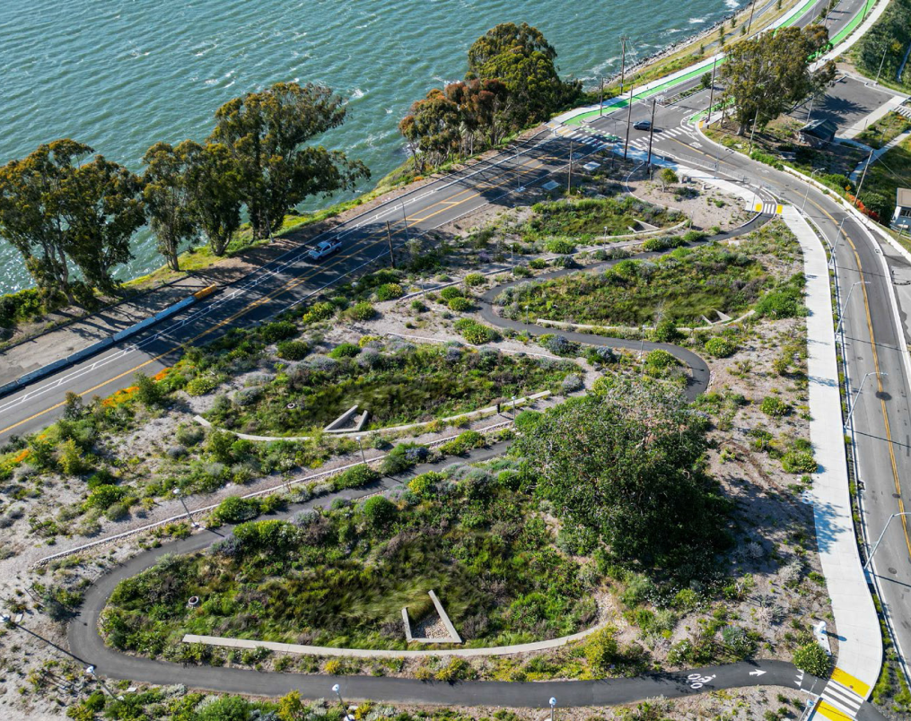
Port – Waterfront Resilience Program
The Waterfront Resilience Program is a major City and Port effort to improve the Port’s 7.5-mile shoreline to provide increased seismic performance, provide near-term flood protection improvements, and plan for long-term resilience and sea level rise adaptation. The Program, with a estimated costs of $13.5 billion plus inflation, reached an important milestone as the U.S. Army Corp of Engineers formally endorsed a Flood Study Draft Plan which charts a path forward to completion of the Flood Study. There remains significant milestones, including a formal recommendation to Congress and subsequent authorization by Congress. Additionally, a G.O. Bond is planned for 2028 which is anticipated to include $250 million for resilience. Ultimately, the Port will require federal, state, and local funding to complete this multi-decade effort.
The Port has identified funds for the Waterfront Resilience Program of approximately $589 million through FY2035.
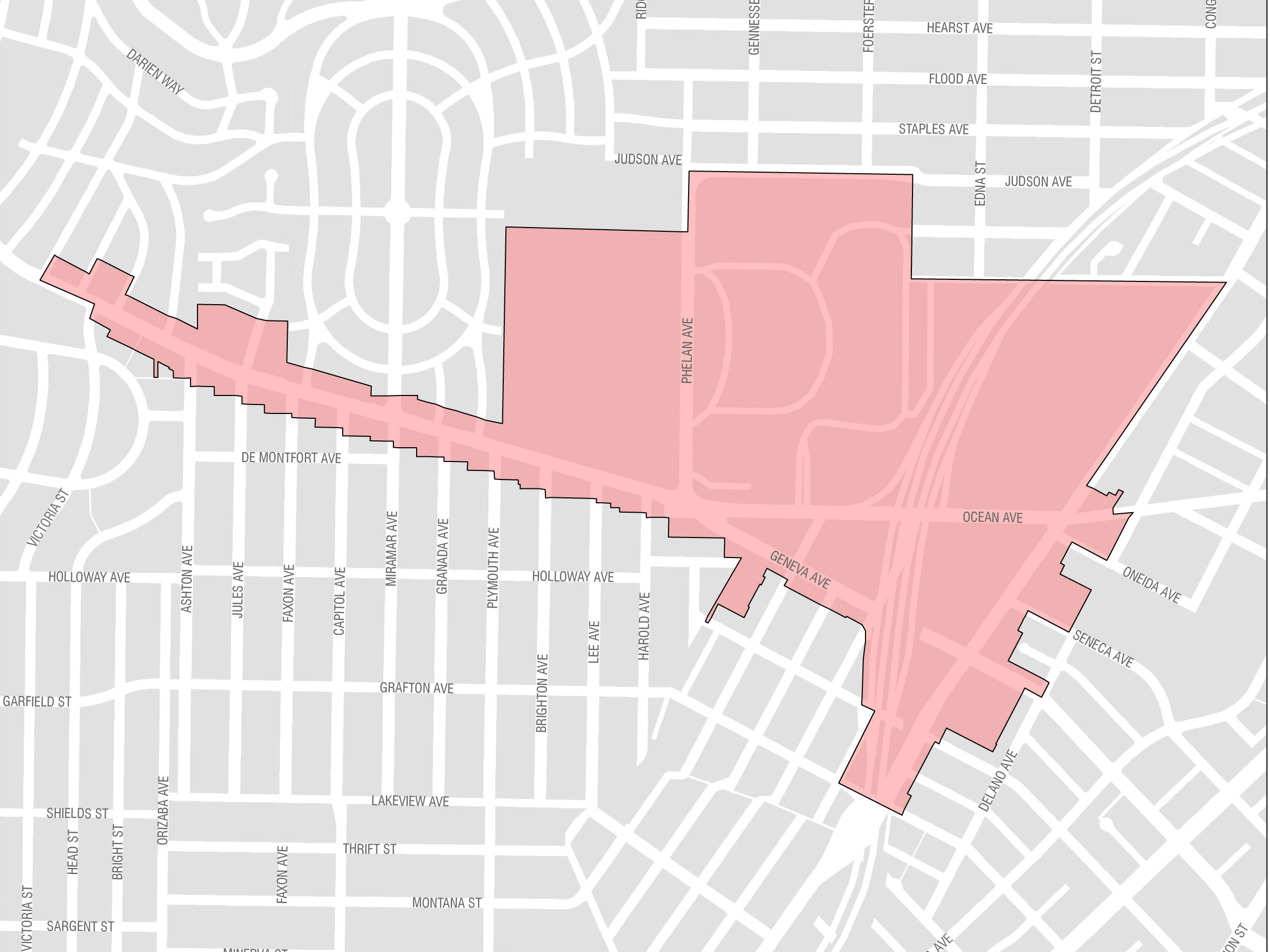
Planning – Balboa Park
Balboa Park is in southern San Francisco and provides several amenities including the Ocean Avenue campus of the City College of San Francisco, the Ocean Avenue Neighborhood Commercial District, Balboa Park, and the Balboa Park BART station. A population increase in this area is anticipated with the planned construction of over 1,000 units of new market-rate and affordable housing units at the Balboa Reservoir.
Most major development in this area is taking place on publicly owned land with few developable privately-owned sites, which means relatively less revenue can flow in from impact fees. For Balboa Park, $2.3 million in impact fees were budgeted through FY2025.
From FY2026 through FY2035, $0.4 million is expected from impact fees. The area’s modest impact fee revenue aims at, among other goals, increasing safety, access, and mobility for pedestrians and transit riders.
Planning – Eastern Neighborhoods
The Eastern Neighborhoods Area Plan consists of several smaller neighborhoods, including the Mission, Showplace Square/Potrero Hill, and Central Waterfront. Much of the land use in the Eastern Neighborhoods was historically dedicated to industrial uses and production, distribution, and repair. New land use policies adopted in 2009 have preserved the use of some land for production, distribution, and repair while also requiring new mixed use and residential development.
Since the Eastern Neighborhoods Area Plan was initiated in 2008, the City has worked with the community to identify priority projects for implementation. Major completed projects include streetscape improvements to Potrero Avenue, Treat Plaza, and 22nd Street; the 16th Street/22-Fillmore Improvement Project; and open space improvements at Garfield Square Aquatics Center, Juri Commons, Esprit Park, and Franklin Square.
For Eastern Neighborhoods, approximately $70 million in impact fee revenue were budgeted through FY2025, with $68 million received through FY2024. From FY2026 through FY2035, an additional $43 million in revenue is anticipated.
Key proposed neighborhood projects for Eastern Neighborhoods include streetscape improvements at the Central Waterfront/Dogpatch, as well as recreational and open space improvements at Mission Recreation Center and Jackson Playground.
Planning – Market Octavia
Market Octavia is located just west of the Civic Center, where governmental and cultural institutions attract visitors both day and night. Its pattern of streets and alleys make it walkable and bikeable, and it is well-served by transit. Market Octavia’s history as a crossroads also poses challenges, with its legacy of large redevelopment projects and heavy vehicular traffic. The Area Plan for Market Octavia identified many needs related to complete streets, transit, open space, and childcare.
Major projects already completed include pedestrian, bike, and/or transit improvements on Upper Market, 13th Street, Page Street, Valencia, and Van Ness, as well as the Margaret Hayward Park renovation.
Through FY2025, $54 million in impact fee revenue was budgeted for Market Octavia. From FY2026 through FY2035, an additional $62 million is anticipated.
Key proposed neighborhood projects for Market Octavia include Muni enhancements, streetscape improvements to 11th Street and 13th Street and a major rehabilitation to the Buchanan Street Mall.
Planning – SoMa
SoMa includes three Area Plan geographies: Western SoMa, Central SoMa, and Eastern SoMa. The vision of the Central SoMa Plan is to create a social, economic, and environmentally sustainable neighborhood by 2040, with space for approximately 32,000 new jobs and 8,600 new housing units. Impact fees and the establishment of a CFD are expected to fund streetscape, transit and open space projects.
Important improvement projects in SoMa have already been completed, including the 2nd Street streetscape and the 27 Bryant Tenderloin transit project, with 6th Street improvements underway.
Through FY2025, approximately $69 million in impact fee revenue has been received/budgeted for SoMa, and no CFD bonds were issued. From FY2026 through FY2035, $199 million more from impact fees are anticipated. The SoMa CFD is expected to generate $288M between FY31 and FY35.
Key proposed SoMa projects include: Folsom/Howard streetscape, Gene Friend Recreation Center, and a new park at 11th & Natoma (Rachele Sullivan Park).
Planning – Visitacion Valley
Visitacion Valley is in southeast San Francisco, near the Brisbane border. New developments at Schlage Lock, Executive Park, and Hope SF, are expected to produce a net increase of 4,800 housing units, 140,000 square feet of commercial/retail space, and 75,000 square feet of community space. An impact fee was implemented in 2005 for Visitacion Valley in anticipation of higher density development from these developments. Delays in the development of these projects from construction costs and the COVID-19 pandemic have limited impact fee revenue collection.
While there is no area plan for Visitacion Valley, several transit, streetscape and recreational projects have been prioritized for the neighborhood in collaboration with City departments. These key projects include Geneva Harney Bus Rapid Transit, 8-Bayshore Transit, Herz Playground rehabilitation, and Schlage Lock streetscape improvement and parks projects.
TIDA – Bridge Access Improvements
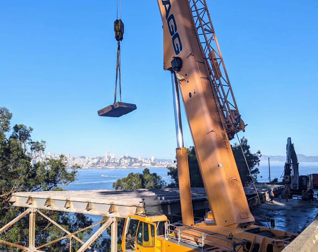
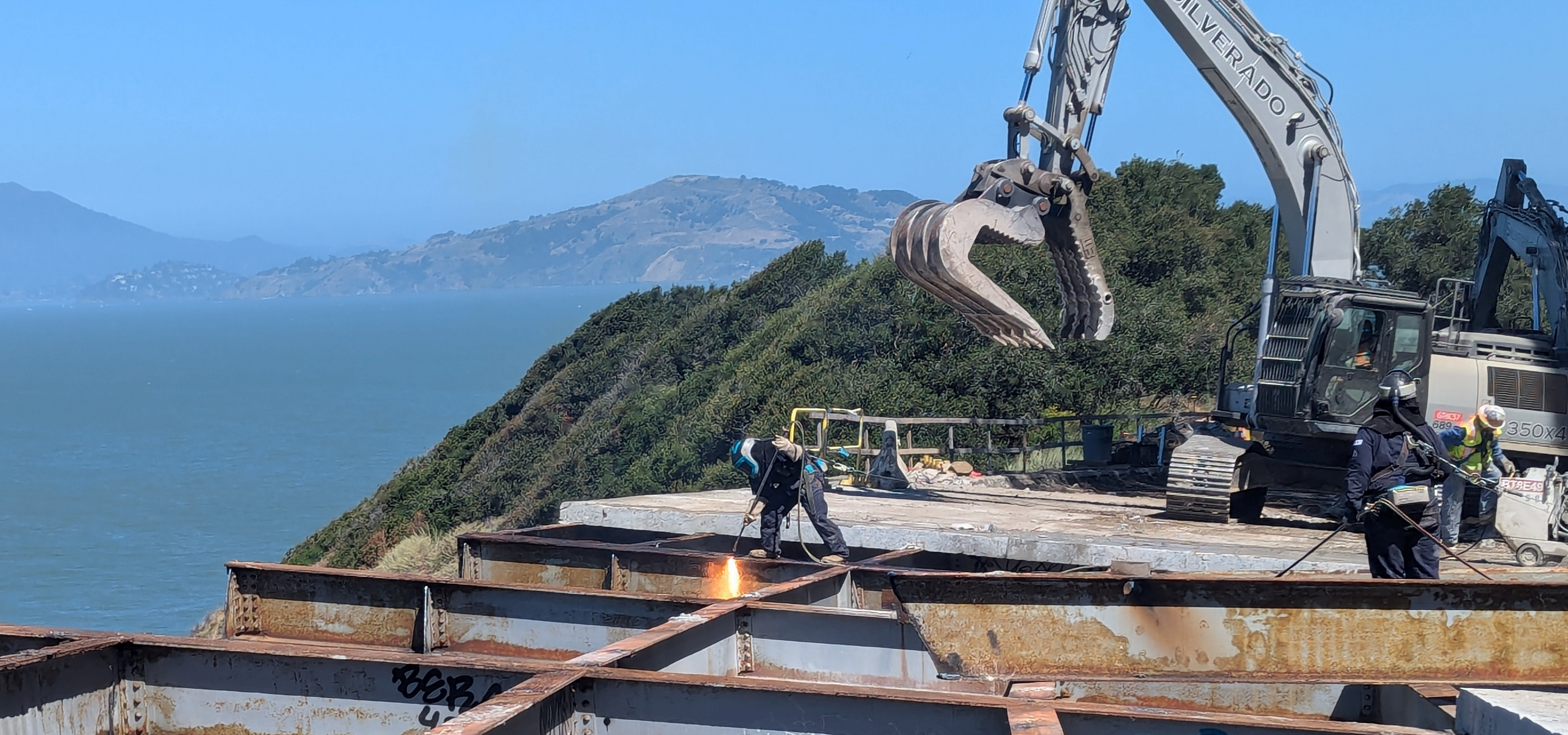
The redevelopment of Treasure Island and Yerba Buena Island required improved access to the islands from the I-80 Bay Bridge and to seismically retrofit or replace the viaduct structures on the west side of Yerba Buena Island. Under the Disposition and Development Agreement (DDA), Infrastructure Plan, and related agreements, these improvements are City obligations, and the San Francisco County Transportation Authority (SFCTA) was to deliver these projects leveraging initial funding commitments from the Federal Highway Bridge Program and State of California Proposition 1B proceeds.
The first of these projects, the new westbound on- and off-ramps, was completed in October 2016. The second project, an interchange between eastbound on- and off-ramps and access roads on Yerba Buena Island began construction in June 2020 and opened in October 2022. The third project to replace the seismically deficient viaduct structures (Westside Bridges Project) is under construction and will be completed by 2026. The fourth project, the Multi-Use Pathway Project, is also being led by the SFCTA and will provide a bike/ped connection from the existing Vista Point at the end of the Bay Bridge East Span along Treasure Island Road to Treasure Island and the new ferry terminal. Timing for the construction of the Multi-Use Pathway is dependent on securing construction funding.
TIDA – Horizontal Infrastructure
As a manmade island, significant work is required to improve the soil conditions on Treasure Island prior to development. Additional soil import is necessary to prepare for anticipated sea level rise. Roadways and utility infrastructure throughout Treasure Island and Yerba Buena Island will need to be replaced to meet City standards and serve the new development. These improvements are, with limited exceptions, the responsibility of Treasure Island Community Development (TICD). Upon completion, this infrastructure will be accepted by the appropriate City Agency. TIDA will not be accepting new horizontal infrastructure, with the notable exception of new parks, as discussed below.
Stage 2/3 of the horizontal infrastructure will commence in Spring of 2025, after the issuance of the City’s Certificate of Participation.
The estimated Stage 2/3 Horizontal Infrastructure project is approximately $150 million, with initial funding from the private capital of the developer and reimbursed by the City’s Certificate of Participation.
TIDA – Public Parks & Open Spaces
The project includes more than 290 acres of new public open spaces including parks, public access trails, shoreline and other waterfront improvements to enhance public use and enjoyment of the San Francisco Bay. The initial development of these facilities is a developer responsibility. Upon completion, the City via TIDA will accept ownership of these facilities. Per City Charter requirements, future operation, renewal, and improvement will be the responsibility of City Staff. The Community Facilities District formed over the islands in 2017 and subsequent formations, in addition to a developer subsidy, intend to provide a stream of revenues to support parks operations.
Ten acres of new parks and open space have been completed on Treasure Island and Yerba Buena Island. New parks include The Rocks Dog Park, Panorama Park and Signal Point, hilltop parks on Yerba Buena Island with 360-degree views, and Treasure Island Landing, an inviting plaza at the transit hub of Treasure Island, and gardens that act as centralized stormwater treatment basins. Cityside Park construction is underway and will be completed Q1 of 2025. Initial built out of all parks and open spaces are the developer’s obligation under the development agreement and funded by private capital and reimbursed by CFD or the City's Certificate of Participation.
TIDA – Transportation Improvements
In its role as the Treasure Island Mobility Management Agency, the SFCTA is responsible for implementing a comprehensive and integrated transportation program to achieve the twin goals of 50% trips by transit/walking/biking and financial sustainability. The mobility program supports the redevelopment of Treasure Island into a new mixed-use and mixed-income neighborhood with 8,000 housing units, 27 percent of them affordable. The centerpiece of this effort is a congestion pricing program that applies motorist user fees to support enhanced bus, ferry and shuttle transit, as well as bicycling options, to reduce the traffic impacts of development. The capital elements of the program include the initial built-out and implementation of the tolling system, ferry charging infrastructure, and program delivery and management costs to deliver the integrated capital program and launch transit services.
This chapter includes agencies and plans that focus on areas of new development, and as a result not all entities and projects have significant renewal programs. Yerba Buena Gardens renewals are addressed in the General Government Service Area.
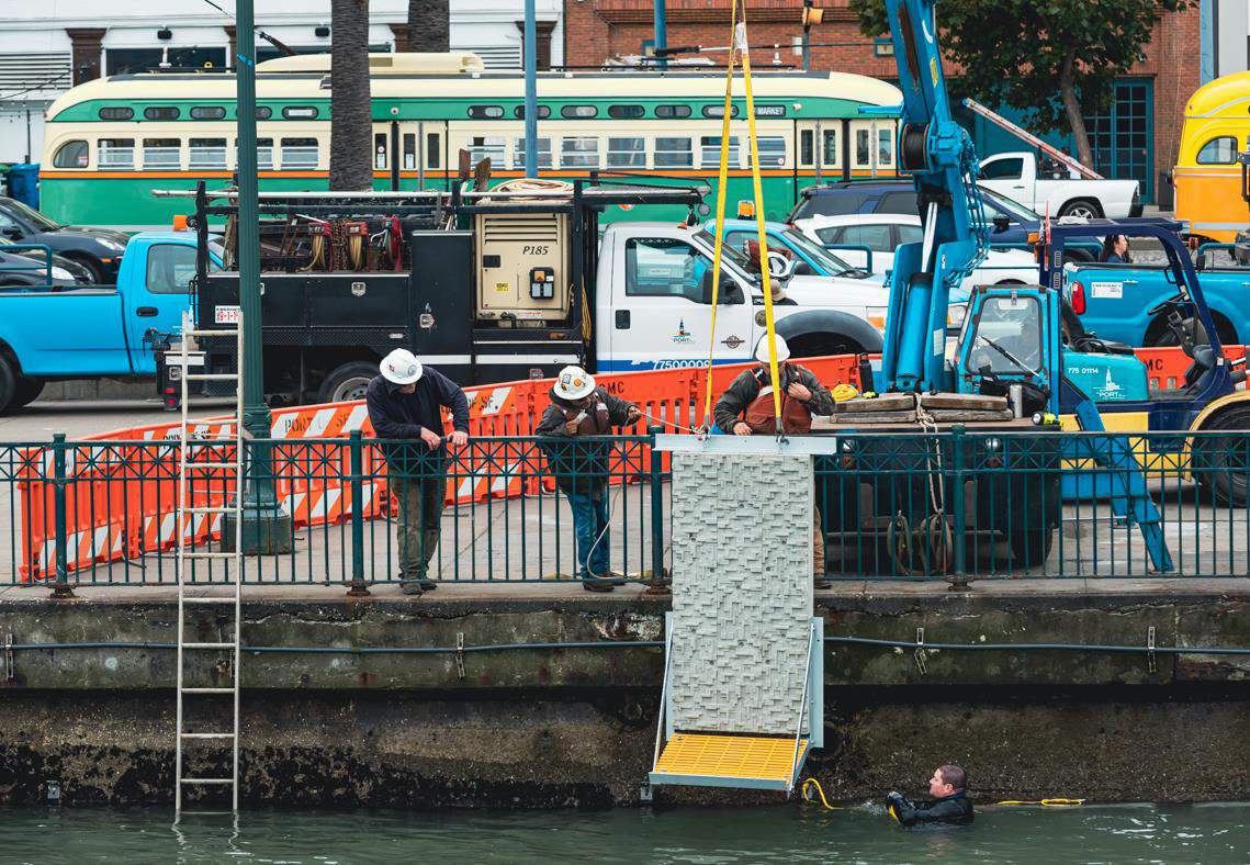
Living Seawall
Port of San Francisco
The Port’s capital program maintains existing resources and, when possible, makes vacant properties fit for leasing to increase the Port's revenue-generating capacity. A substantial portion of the Port’s facility renewal budget supports pier structure repairs to ensure the continued safe operation of pier superstructures and buildings, the preservation of lease revenues, and the extension of the economic life of the Port's pier and marginal wharf assets.
The Port’s renewal program includes maintenance dredging, which ensures the proper depth of berths at the Port’s piers so that they remain suitable for water traffic. Maintenance dredging is necessary to keep the Port's berths and channels at navigable depths, including sites where the Port has contractual obligations with shipping lines and operators.
The one-time cost category primarily captures non-cyclical improvements, typically driven by changes in code requirements. Such work includes relocating under-pier utilities above the pier, as well as remediating structures at Pier 70. For many of these structures, partial rehabilitation is not a viable option and any rehabilitation will trigger substantial seismic work. As a result, the Capital Plan reflects these facilities as one-time costs for rehabilitation or demolition until they are fully improved and a capital maintenance cycle commences.
The Engineering Division regularly conducts inspections of all Port facilities and categorizes the condition of more than 350 of the Port’s structures, including piers, wharves, and buildings. In addition to staff inspections, the Port performs a consultant-supported condition assessment of select Port facilities. The condition assessments gather data on pier substructure, building structural systems, building envelope, utilities, and egress and accessibility. This assessment process provides staff with critical inputs to help define the full scope and cost of each assessed facility into a state of good repair. The Port performs these assessments every other year.
TIDA - Chapel
The existing Chapel that is owned by TIDA underwent structural improvements of the steeple and received a new roof in advance of beginning construction of the park that will surround the structure. In 2023, the master developer TICD will continue improvements on the Chapel including exterior paint, new ADA entry, new ADA-compliant restrooms, and interior upgrades. Construction of the surrounding park is also scheduled to begin in 2025.The existing Chapel that is owned by TIDA underwent structural improvements of the steeple and received a new roof in advance of beginning construction of the park that will surround the structure. In 2023, the master developer TICD will continue improvements on the Chapel including exterior paint, new ADA entry, new ADA-compliant restrooms, and interior upgrades. Construction of the surrounding park is also scheduled to begin in 2025.
OCII: Office of Community Investment and Infrastructure
PLANNING: Neighborhood Development
PORT: Port of San Francisco
TIDA: Treasure Island Development Authority
Bayfront Park
Despite the short-term uncertainty brought on by the economic impacts of the pandemic, San Francisco is expected to grow. In 2023, the population was 808,988, an 8% drop from 2019 but up 4% from 2000. The current draft of Plan Bay Area 2050+, developed by the Association of Bay Area Governments, projects San Francisco will grow by 150,000 households (approximately 300,000 people), and 200,000 jobs by 2050. Though lower than pre-pandemic estimates, these projections still represent significant population and density increases, and planning for sufficient infrastructure to support all residents in all neighborhoods remains as important as ever.
Before 2020, the majority of the new developments in San Francisco were concentrated in the eastern part of the city, including Central SoMa, Market Octavia, Mission Bay, Treasure Island, Central Waterfront (Potrero Power Station + Pier 70), and Candlestick Point. Many of these areas are low-lying and are vulnerable to sea level rise, flooding, and liquefaction, and as former industrial areas have fewer services and infrastructure to support the increases in population, which required planning for targeted improvements in open space, transit, complete streets, and community facilities. Major developments and planning for housing growth in other parts of the City are advancing now as well, notably on the westside and northern parts of the City as part of San Francisco’s broader Housing Element rezoning. Some of these plans and developments have distinctive funding mechanisms, including dedicated development fees and development agreements, while others rely on citywide fee structures.
Mission Rock
Mission Rock Parcel B
Overview
Development in San Francisco continues to progress, if at a different pace and trajectory than projected pre-pandemic. Adjusting to current and projected population trends will bring different mixes of needs and uses for impact fees and other infrastructure sources. The City will continue to plan its available capital funds to build San Francisco’s evolving neighborhoods as great places to live, travel, work, and play.
New development, densifying, and repurposing existing sites for housing can bring public infrastructure needs, particularly in areas transitioning from commercial or industrial. As existing residential areas densify, the City will need to monitor usage patterns and the adequacy of the service levels and plan investments as necessary to augment existing facilities and infrastructure. Transportation systems must be made more efficient to handle increased ridership and shifts to different modes. San Francisco’s sidewalks and public right-of-way must be enhanced so that pedestrians can move about safely. Residents must have access to open space that meets the recreational and respite needs of the city’s growing population. Delivering public infrastructure when development requires, helps to create safe, livable neighborhoods and projects for San Francisco’s residents, workers, and visitors. Doing so in a climate of more tightly constrained revenue will be a near-term challenge for the City. Sources to implement infrastructure projects that support economic and neighborhood development projects include impact fees, General Fund, bonds, grants from the federal government, the State of California or private philanthropy, and other local funds such as Proposition K sales tax dollars and revenues from Community Facilities Districts (CFDs). San Francisco also continues to encourage and expedite housing development using Infrastructure Financing Districts (IFDs). As of publication, in addition to redevelopment areas, IFDs have been formed at Treasure Island, Pier 70, Potrero Power Station, and Stonestown, with additional districts pending and on the horizon. More information about this funding source and its policy constraints can be found in the Introduction and in the Capital Sources Chapters.
To accommodate increases in population, over the past two decades San Francisco has amended its General Plan with several area plans, which guide the land use and other aspects of development for a given specific geographic area. The area plans have development impact fees to fund infrastructure located in those neighborhoods – Balboa Park, Eastern Neighborhoods, Market Octavia, Rincon Hill, Transit Center, and SoMa – with a similar fee structure for planned growth in Visitacion Valley as well. Impact fee revenue has declined since the pandemic due to the decline in development taking place. The City continues to seek sources in order to complete priority projects.
Over the past couple years, San Francisco has adjusted its development requirements in order to improve the feasibility and encourage delivery of new housing. Passed in 2023, San Francisco’s inclusionary housing and impact fee reform legislation temporarily lowered inclusionary housing requirements and reduced development impact fees citywide by one-third for projects approved by November 1, 2026. Fee reform also permanently allowed developers to defer 80% of their impact fees from initial permit issuance until Temporary Certificate of Occupancy, which significantly alters the revenue flow for infrastructure improvements. These changes improve financial feasibility and reduce risk for housing builders; however, they will also reduce the amount of fee revenue that will be available to fund public infrastructure projects and extend the timeline of those projects.
Acknowledging decreased near-term demand for office space and the current high commercial vacancy rate, the need for housing citywide, and a goal of bringing new residents and students downtown, policy makers have approved legislation to allow for more housing and greater land use flexibility. Recent legislation was passed to streamline permitting, waive Planning Code requirements, and clarify Building and Fire Code requirements to convert commercial buildings to housing Downtown. Building on these regulatory changes, new legislation at the local and state level will support the financial feasibility of adaptive reuse projects. In March 2024, voters approved Proposition C which waives the real estate transfer tax for adaptive reuse projects, eliminating a significant cost for these projects. The recently passed state bill AB2488 seeks to accelerate the adaptive reuse of commercial buildings by enabling the formation of an enhanced infrastructure financing district (EIFD) downtown. Local legislation has also been proposed to waive development impact fees and requirements, including the Inclusionary Housing fee for adaptive reuse projects Downtown.
In the Central SoMa and Transit Center District plan areas, policy makers have proposed legislation to increase capacity for housing. The primary engine for community benefits in the Central SoMa (and to some extent, the Transit Center District) plans was commercial development and associated impact fees, CFD special taxes, and in-kind direct provisions of facilities. If realized, a shift of land use from commercial to residential would yield a lower financial contribution from impact fees to fund infrastructure projects in these plan areas as thousands of additional housing units are added. Depending on the types of uses that are ultimately built, additional or different infrastructure and community facilities to serve this larger residential population may be needed and new funding sources identified.
Though impact fees and other sources will be constrained in the near term, San Francisco will continue to plan for complete, livable neighborhoods. The City’s Housing Element rezoning effort is premised on proximity to certain core infrastructure and services, such as major transit lines. That broader rezoning relies on generally prevailing existing citywide impact fee structures and is not likely to propose new fees specific to this broad citywide rezoning. The City generally, and the capital plan specifically, need to assume that impact fees, even in the best of economic times, are always a supplemental, and not the primary, source of funding long-term capital needs to support growth.
This chapter includes capital projects from departments, agencies, and programs whose primary objectives are to improve San Francisco’s wide-ranging economic base and plan for its future growth.
Treasure Island Infrastructure
Yerba Buena Island Bridge
Port of San Francisco
The Port of San Francisco is responsible for the 7.5 miles of San Francisco waterfront adjacent to San Francisco Bay. The Port manages, maintains, develops, markets, and leases all of the property in this area. The Port’s operating portfolio is composed of approximately 580 ground, commercial, retail, office, industrial, and maritime leases, including leases of many internationally recognized landmarks such as Fisherman’s Wharf, Pier 39, the Ferry Building, and Oracle Park, home of the San Francisco Giants baseball team.
Port lands must be used consistently with public trust principles for the benefit of all California citizens, to further navigation and maritime commerce, fisheries, public access and recreation, environmental restoration, and commercial activities that attract the public to the waterfront. Urban waterfront developments, including the new Southern Bayfront neighborhood developments proposed in the Mission Rock, Orton, and Brookfield projects, require detailed coordination, review, and approval of many government agencies. The Port has also secured State legislation to allow non-trust uses of specified Port lands and created special financing districts to support waterfront improvements.
Such advances were made possible by developing a common understanding with partner agencies of project objectives and requirements to restore historic structures and improve the waterfront for maritime and public use and enjoyment.
Caring for the Port’s many aging, historic structures while staying true to its public trust mission is a challenge. The Port’s need for capital investments has historically outpaced available funding, leaving a substantial backlog and requiring strategic decisions about how to best manage the Port’s aging assets. The Port has confronted this challenge with dedicated funds, pursuit of new external sources, and strategic prioritization.
Office of Community Investment and Infrastructure
The Office of Community Investment and Infrastructure (OCII) is the successor agency to the San Francisco Redevelopment Agency, which was dissolved in 2012 by order of the California Supreme Court. OCII is authorized to continue to implement the Major Approved Development Projects, which include the Mission Bay North and South Redevelopment Project Areas (Mission Bay), the Hunters Point Shipyard Redevelopment Project Area and Zone 1 of the Bayview Redevelopment Project Area (Shipyard/Candlestick Point), and the Transbay Redevelopment Project Area (Transbay).
The Mission Bay development covers 303 acres of land between the San Francisco Bay and Interstate-280. The development program for Mission Bay includes market-rate and affordable housing, new commercial space, a new UCSF research campus and medical center, neighborhood-serving retail space, a 299-room hotel, new public open space, and a myriad of community facilities.
The Shipyard/Candlestick Point is comprised of nearly 692 acres of abandoned and underutilized land along San Francisco’s southeastern Bayfront. These long-abandoned waterfront lands will be transformed into areas for jobs, parks, and housing. The development will feature up to 12,100 homes, of which nearly one-third will be affordable, 4.9 million of office and research and development, 2.8 million square feet of retail, community facility, institutional and entertainment uses.
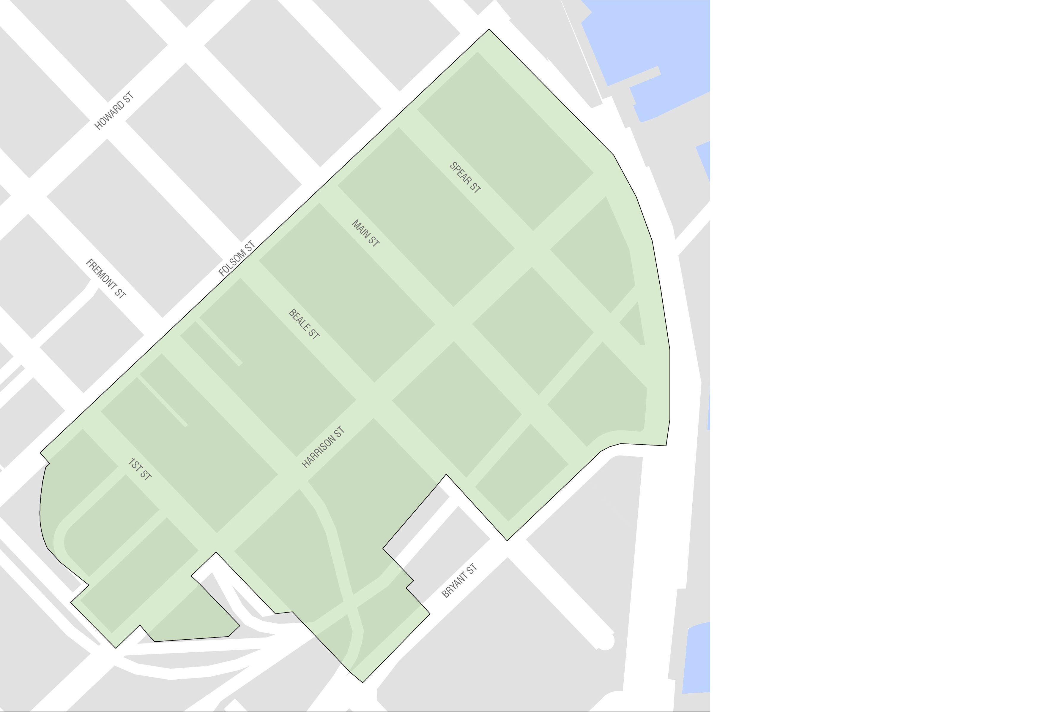
The Transbay development includes the new Salesforce Transit Center and ten acres of former freeway parcels, which OCII and the Transbay Joint Powers Authority (TJPA) are developing into a new, mixed-use neighborhood surrounding a state-of-the-art, multi-modal transit station. The TJPA is responsible for constructing, owning and operating the new Transit Center, and OCII is responsible for the development of the surrounding neighborhood. At full build-out, these publicly-owned parcels will be transformed into approximately 3,300 new housing units, including nearly 1,400 affordable units, three million square feet of new commercial development, and 3.4 acres of parks and open space.
Treasure Island Development Authority
Treasure Island and Yerba Buena Island are in San Francisco Bay, about halfway between the San Francisco mainland and Oakland. Treasure Island contains approximately 404 acres of land, and Yerba Buena Island, approximately 150 acres.
The Treasure Island/Yerba Buena Island Development Project (the Project), is building a new San Francisco neighborhood consisting of up to 8,000 new residential housing units, as well as new commercial and retail space. The Project has completed the first stage of infrastructure, ten acres of new parks and open space and 1000 units of housing. Upcoming work will feature new hotel accommodations and 300 acres of parks and public open space, including shoreline access and cultural uses. Transportation amenities being built for the Project will enhance mobility on the Islands as well as link the Islands to San Francisco. These amenities include new and upgraded streets and public byways; bicycle, transit, and pedestrian facilities; landside and waterside facilities for the existing Treasure Island Sailing Center; an expanded marina; and a new Ferry Terminal.
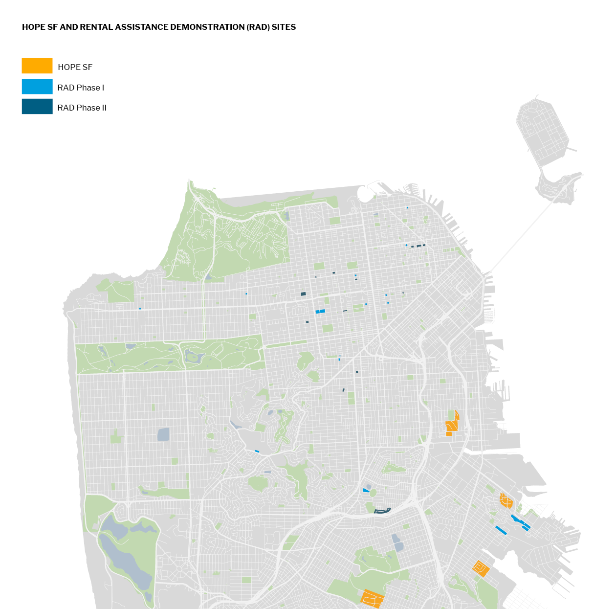
HOPE SF
HOPE SF is an anti-poverty initiative that works to revitalize San Francisco’s largest and most distressed public housing sites as mixed-income developments. The HOPE SF public housing sites are Hunters View, Alice Griffith, Potrero Terrace and Annex, and Sunnydale and Velasco. All of these projects are former San Francisco Housing Authority sites, now being converted to private management. The real estate and infrastructure component of HOPE SF requires the complete demolition and rebuilding of the four sites along with the creation of new streets, parks and open spaces, and community space that will physically reconnect these sites to their surrounding neighborhoods. These projects also replace and generate new affordable housing units, which is discussed in further detail in the Affordable Housing Chapter.
Planning Department
The Planning Department, in collaboration with other City Departments and the public, develops plans for the City’s existing and evolving neighborhoods to meet the needs of current and future residents, workers, and visitors. Over the last twenty years, community planning to create capacity for more housing has been primarily focused on the southeast part of the city with the adoption of area plans including Balboa Park, Eastern Neighborhoods, SoMa, Market & Octavia, Rincon Hill, and Transit Center. With the adoption of the City’s Housing Element led by the Planning Department in 2023, the City will increase capacity for housing on the west and northern part of the city as well to satisfy the City’s Regional Housing Needs Allocation (RHNA). Together with the Office of Economic and Workforce Development, Planning also leads the implementation of the downtown economic revitalization as part of Former Mayor Breed's Roadmap to San Francisco’s Future.
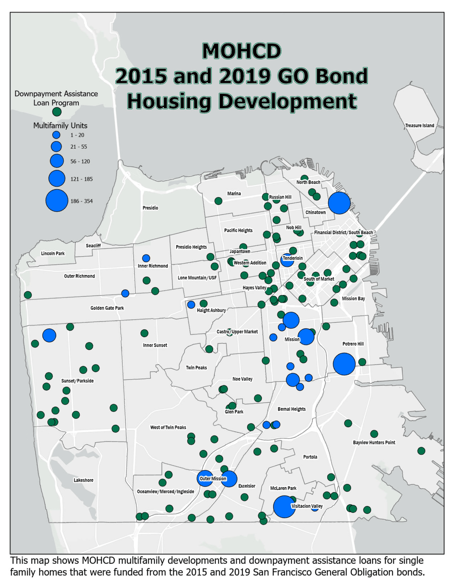
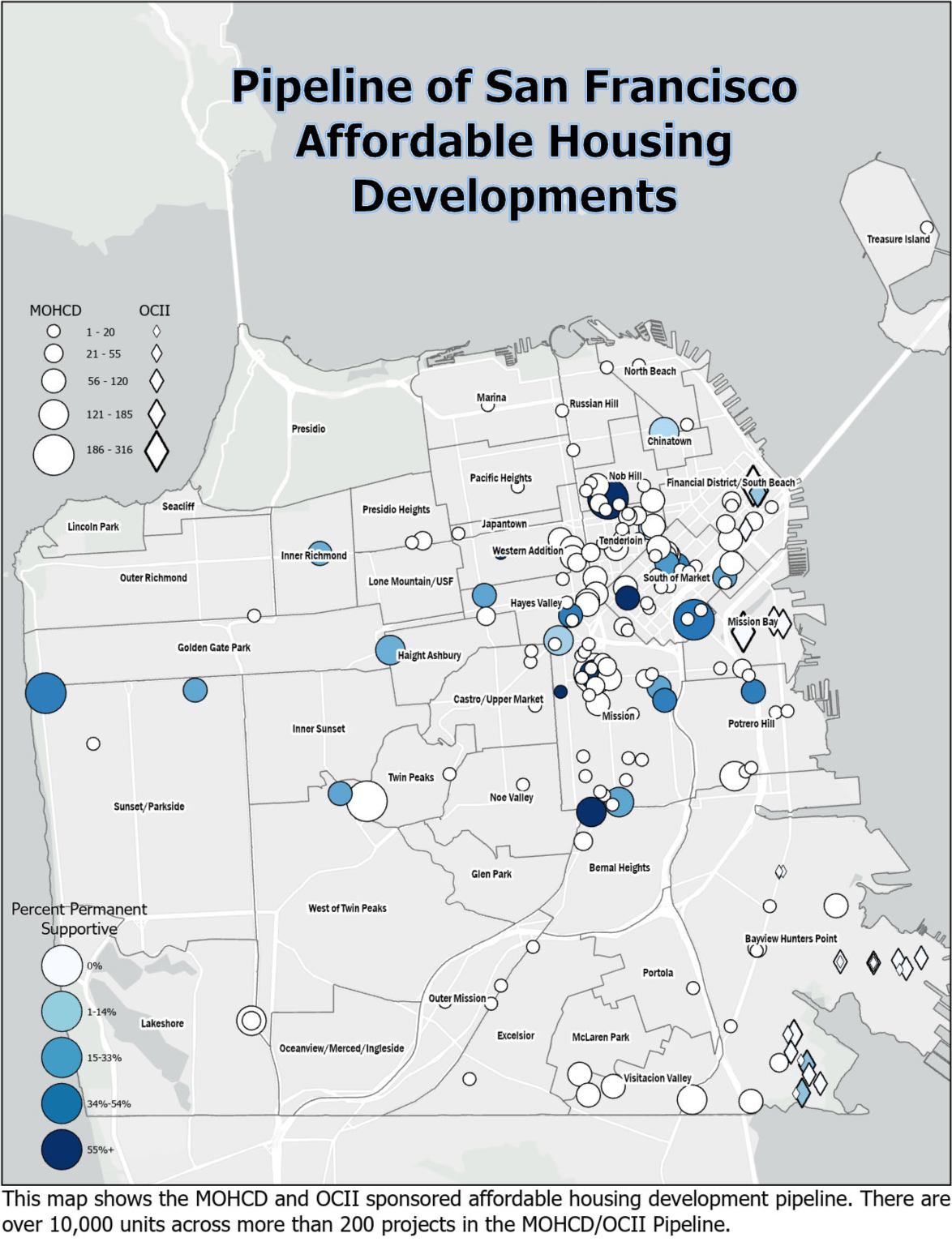
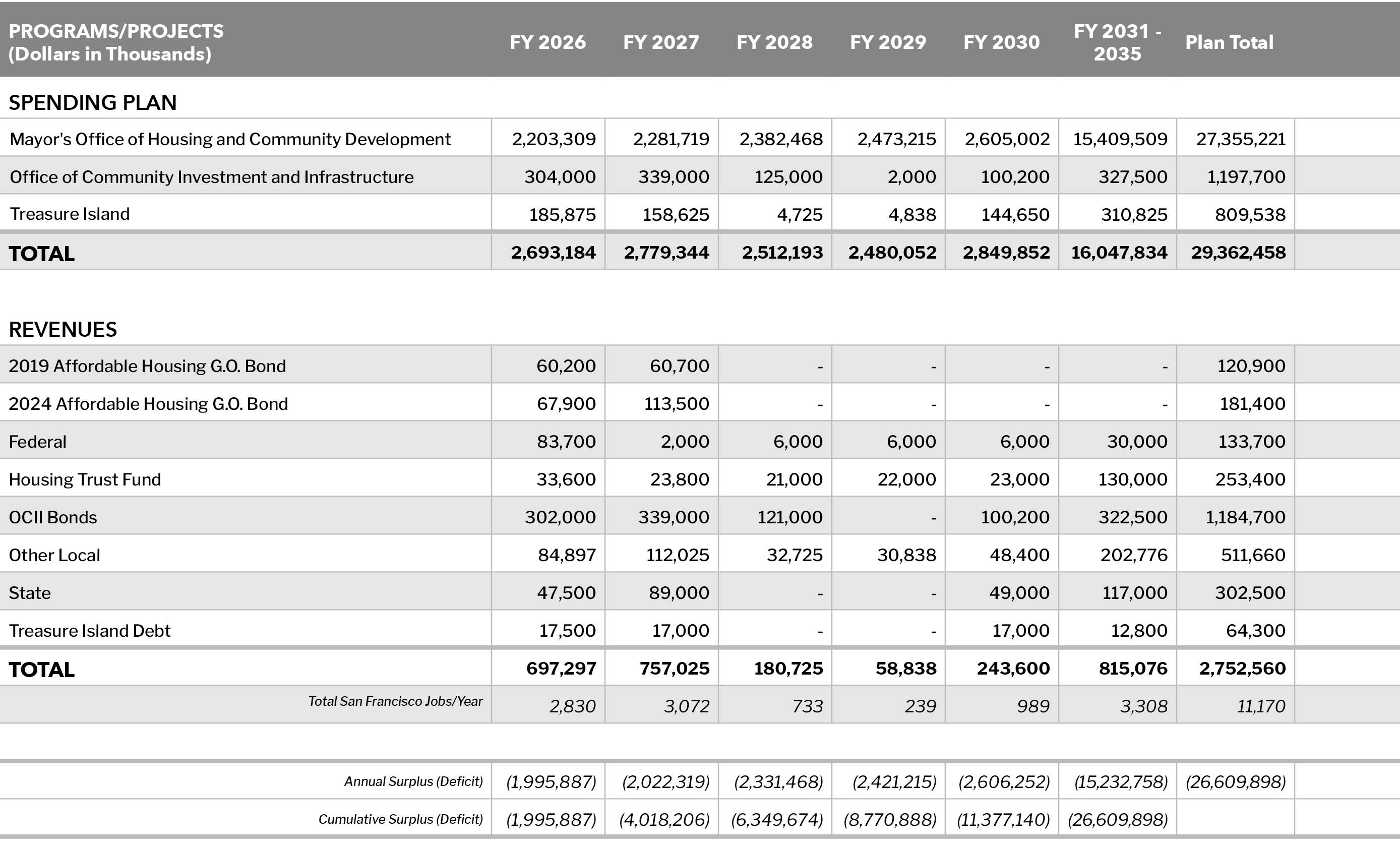
MOHCD’s planned projects need to meet key criteria for other public investment, including scale, readiness, proximity to public transit, ability to leverage non-City sources of funding, and location in high resource neighborhoods, as defined by the State. The pipeline includes: 100% affordable multifamily buildings that are either stand-alone developments or part of multi-phased development areas, and below-market-rate (BMR) inclusionary units in market-rate buildings. MOHCD’s pipeline includes all projects that are financed through city funding agreements, ground leases, disposition and participation agreements and conduit bond financing. Affordable housing developments, such as state-funded projects, that do not meet these criteria are not included in the pipeline.
The pipeline of 10,670 affordable units in 212 projects is an ambitious and significant commitment to producing more affordable housing in San Francisco. However, many more units are needed to meet the 2022 Housing Element goals, and the City will need to pursue opportunities and continue to prioritize affordability into the future.
Future projects are opportunities to expand MOHCD’s pipeline that are not currently accounted for in MOHCD’s pipeline and allocations budget. Non-deed-restricted moderate-income housing is produced primarily through the City’s Accessory Dwelling Unit (ADU) program.
To meet 100% of the Housing Element targets, excluding the portion that is projected to be met through inclusionary units, the total housing expenditure plan would need to increase by approximately $25.1 billion. Meeting this full RHNA allocation requires funding and policy decisions outside the purview of the Capital Plan and would depend on the contribution of inclusionary units delivered through market rate production, which is extremely difficult to model. San Francisco strives to deliver as much affordability as possible while meeting other urgent challenges in its public capital portfolio and other service obligations.
Planning – SRO Rehab Assessment
Planning is launching a study to evaluate rehab needs and conduct cost benefit analysis for various scenarios of rehab for existing SROs in the Tenderloin. The results of this analysis will inform priority properties for rehab, the scale of investment needed, or other solutions needed to provide dignified standards of living in SROs that are a critical City asset to provide housing for extremely low-income households. This work began in 2024 and is intended to be complete by early 2026.
TIDA – Inclusionary Affordable Developments
Vertical Developers have multiple rental and condominium projects in the second Sub-Phase area in various stages of planning and building permit review and are expected to start construction in the next two years. These buildings will include for-rent and for-sale inclusionary affordable units.
TICD has demolished most structures within the third Sub-Phase area and geotechnical improvement of soil is underway, with street improvements and infrastructure work expected to start early 2025.
TIDA – Affordable
Housing Developments
The third Sub-Phase area includes four additional parcels for the development of 100% affordable housing. The Behavioral Health Building, which includes a minimum of 240 residential step-down beds, received Vertical Development Approval from San Francisco Planning in August 2024 and is expected to start construction early 2026. The Senior Housing building will include up to 120-units, and the building on parcel IC4.3 will include 150-units. Both the Senior Building and IC4.3 development are currently under design and preparing to submit applications to SF Planning for Vertical Development Approval for construction starts in 2026. Parcels E2.3/4 will include the last 100% affordable housing building in the third Sub-Phase area to be completed and is expected to include 155-units. Predevelopment work for parcel E2.3/4 has not yet started.
In 2014, the Public Lands for Housing Program was created and identified publicly owned sites within the City that could provide new housing. The Balboa Reservoir, a nearly 17-acre surface public parking across from City College of San Francisco (CCSF) and owned by the San Francisco Public Utilities Commission (SFPUC), is the largest site identified by this program. The SFPUC and the Master Developer executed the Development Agreement in 2021, upon approval of the entitlements.
The project will consist of approximately 1,100 units of housing, of which 50% would be market-rate. The affordable units will be for low-income households up to 80% AMI and moderate-income households, including educator households for CCSF and San Francisco Unified School District, up to 130% AMI. The first affordable project is anticipated to start construction June 2025 and second affordable in December 2025.
All of MOHCD’s local sources of funding are eligible for new production like that planned for Balboa Reservoir, with the exceptions noted in the planned very low and low income and moderate-income housing program narratives above. However, MOHCD’s allocations budget is fully programmed, and only a portion of the funding needed to support the additional 33% of affordable housing has been identified.